Abstract
Autonomous navigation in unstructured agricultural and forestry environments demands high-fidelity, real-time 3D mapping to support safe and efficient motion planning. This survey systematically reviews dense mapping techniques, spanning grid-based, octree, surfel, mesh, and neural implicit representations, and evaluates their suitability for mobile robots operating under variable terrain and foliage cover. We begin by examining common sensor modalities (monocular/stereo cameras, RGB-D, LiDAR, mmWave radar) and their integration into mapping frameworks such as TSDF/ESDF, OctoMap, Voxblox/Nvblox, and NDT-OM. Next, we detail adaptations of these methods for agricultural and forestry applications. Finally, we address the emerging challenge of estimating solid ground beneath vegetation and constructing traversability maps through statistical models, proprioceptive–exteroceptive fusion, radar sensing, and self-supervised deep learning. By comparing state-of-the-art algorithms and datasets, we identify key trade-offs between memory efficiency, map fidelity, and real-time performance. We conclude with recommendations for integrating uncertainty-aware and active-perception strategies, and outline future directions toward scalable, cloud-based, multi-robot mapping for precision agriculture and forestry management.
keywords Dense mapping Motion planning Agricultural robotics Forestry robotics Traversability analysis Solid ground estimation
At a glance
A short structured summary of the article, written from its abstract and conclusions.
- Scope: dense (not sparse/SLAM-only) 3D mapping for ground robots that must plan motion through unstructured, vegetation-rich farmland and forest.
- Sensors compared: monocular and stereo cameras, RGB-D / structured light, mmWave radar and LiDAR, by cost, accuracy, resolution, range, compute and robustness to the environment.
- Map representations reviewed: grids and voxels, octrees (OctoMap), surfels, meshes, TSDF/ESDF (Voxblox, Nvblox), NDT-OM and neural implicit maps, classified by data structure, cell content and hierarchy.
- Agricultural and forestry adaptations: volumetric and multi-resolution mapping, semantic and collaborative (multi-robot, air–ground) mapping, depth completion and sensor fusion under foliage.
- Solid ground under vegetation: statistical terrain models, proprioceptive–exteroceptive fusion, radar that penetrates foliage, and self-supervised learning from the robot's own trajectory, feeding traversability maps.
- Main trade-off identified: memory efficiency vs. map fidelity vs. real-time performance; future work points to uncertainty-aware and active perception and scalable cloud-based multi-robot mapping.
Cite this article
Please cite the published version via its DOI: https://doi.org/10.1109/ACCESS.2025.3638877.
IEEE (plain text)
I. Esfandiyar and D. Belter, "Mapping the Unseen Ground: A Survey on Dense Mapping and Traversability Methods for Agricultural and Forestry Robots," in IEEE Access, vol. 13, pp. 204285-204314, 2025, doi: 10.1109/ACCESS.2025.3638877.
BibTeX
@ARTICLE{11271426,
  author={Esfandiyar, Iman and Belter, Dominik},
  journal={IEEE Access},
  title={Mapping the Unseen Ground: A Survey on Dense Mapping and Traversability Methods for Agricultural and Forestry Robots},
  year={2025},
  volume={13},
  number={},
  pages={204285-204314},
  keywords={Cameras;Robots;Robot sensing systems;Forestry;Three-dimensional displays;Robot vision systems;Vegetation mapping;Estimation;Accuracy;Visualization;Dense mapping;motion planning;agricultural robotics;forestry robotics;traversability analysis;solid ground estimation},
doi={10.1109/ACCESS.2025.3638877}}RIS
TY  - JOUR
TI  - Mapping the Unseen Ground: A Survey on Dense Mapping and Traversability Methods for Agricultural and Forestry Robots
T2  - IEEE Access
SP  - 204285
EP  - 204314
AU  - I. Esfandiyar
AU  - D. Belter
PY  - 2025
DO  - 10.1109/ACCESS.2025.3638877
JO  - IEEE Access
IS  -
SN  - 2169-3536
VO  - 13
VL  - 13
JA  - IEEE Access
Y1  - 2025
ER  -
1 Introduction
The global agricultural landscape faces unprecedented challenges driven by population growth, climate variability, and land degradation. By 2050, the world population is projected to increase from 7 to 10 billion, placing immense pressure on food production systems [1]. Concurrently, urbanization is expected to swell from 50% to 70% of the global population, exacerbating rural labor shortages and amplifying the need for automation in agriculture. Precision agriculture, leveraging data-driven insights to optimize inputs and maximize yields, has emerged as a key strategy to meet these demands sustainably [2].
Mobile robotics promises to revolutionize agricultural operations by automating tasks such as planting, weeding, and harvesting, while conserving resources like water, nutrients, and agrochemicals [3]. To date, most robotic deployments have been confined to structured settings, greenhouses, vineyard rows, and orchards, where regular geometry simplifies navigation and perception [4]. Extending autonomy to unstructured fields and natural forests requires robust mapping and localization in uneven terrain and through dense vegetation.
Traditional remote-sensing platforms, satellites, manned aircraft, and drones, provide valuable overhead views but are hindered by weather dependency, regulatory constraints, and limited spatial resolution near the ground [5]. Ground robots, in contrast, can acquire high-fidelity, multi-modal data at close range, day or night, under foliage canopies. Yet, to plan safe and efficient motions, these platforms require dense, up-to-date 3D models that capture both visible obstacles and hidden hazards rocks, ditches, and water bodies concealed by vegetation (Fig. 1).
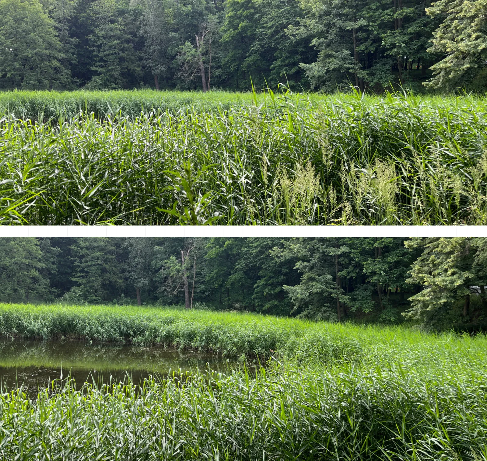
Several reviews have surveyed mapping and localization in agricultural and outdoor robotics, but their focus remains on sparse or functional maps tailored to Simultaneous Localization and Mapping (SLAM) and positioning rather than on dense reconstructions for collision avoidance and motion planning. For example, Fasiolo et al. provide a broad overview of sensing and mapping technologies for ground robots in agriculture [6], [7], while Aguiar et al. examine localization and mapping advances across agriculture and forestry, emphasizing GNSS-based and Feature-Based approaches [8]. Other general surveys explore mobile-robot mapping techniques and SLAM paradigms across domains [9], [10], [11], [12], [13], [14], [15], [16], but none have specifically examined dense mapping techniques aimed at traversability estimation under vegetation. In contrast, this review bridges that gap by specifically targeting dense and traversability mapping methods that support motion planning in unstructured, vegetation-rich environments. Techniques are highlighted for:
generating high-resolution 3D models suitable for collision checking and path planning,
estimating “hidden” ground surfaces beneath vegetation and detecting occluded hazards,
annotating maps with semantic and traversability information essential for agricultural tasks.
The paper is organized as follows. Section 2, introduces the main sensor modalities and dense mapping representations, including grids, octrees, surfels, meshes, and neural fields. Section 3 discusses how these methods have been adapted to agricultural and forestry environments, highlighting advances in semantic fusion and multi-platform cooperation. Section 4 addresses the emerging challenge of solid-ground estimation beneath vegetation and its role in traversability mapping.
Throughout the paper, particular attention is given to the trade-offs between mapping accuracy, computational efficiency, and real-time adaptability, factors that determine whether dense reconstructions can effectively support safe and practical robot navigation. Estimating the solid ground beneath vegetation is emphasized as a key requirement for generating traversable terrain representations in agricultural and forested environments, where uneven topography and occlusions often obscure direct observations. Finally, future directions for integrating uncertainty, active perception, and cloud-based multi-robot mapping are discussed in conclusion.
Given that this review focuses on dense mapping techniques for ground mobile robots in agricultural and forestry environments, certain exclusion criteria were applied to maintain relevance. Specifically Indoor mapping approaches were included only if they demonstrated clear potential for adaptation to outdoor environments. Unmanned Aerial Vehicle (UAV)-based mapping techniques were considered only when they showed applicability to ground-based robotic platforms, such as those integrating aerial and terrestrial mapping for enhanced environmental understanding.
Following the review of general dense mapping algorithms, studies explicitly dealing with high-resolution or dense mapping/reconstruction techniques applied in agricultural fields or forest/woodland environments were included. Studies clearly outside this scope (for example, those focusing on sparse mapping, unrelated domains, or non-robotic contexts) were excluded.
Furthermore, studies addressing the estimation of solid ground surfaces beneath vegetation were included, its importance for safe and reliable operation in natural environments being duly recognized. In these works, a range of techniques including model-based approaches, sensor fusion, proprioceptive feedback, radar sensing, and learning-based methods are applied to recover the underlying terrain obscured by vegetation. The resulting estimations are acknowledged as playing a critical role in the improvement of traversability analysis and motion planning for mobile robots operating safely in agricultural and forestry environments.
2 Mapping for Mobile Robots
In this section, we review recent advances in mapping approaches that span implicit, volumetric, semantic, hierarchical, and elastic representations, highlighting how they address the key challenges of scalability, efficiency, and robustness in real-world robotic applications. These methods leverage multi-sensor fusion, optimized data structures, and learning-based generalization strategies to improve reconstruction accuracy, reduce computational overhead, and enhance adaptability to dynamic environments. Complementing these developments, publicly available datasets provide diverse benchmarks for evaluating mapping performance across both simulated and real-world scenarios.
2.1 Sensor Modalities
The following section outlines key hardware technologies that are utilized for dense mapping and localization in mobile robotics, by providing targeted insight into various sensor modalities that play distinct roles in capturing environmental data and examines the capabilities and limitations of each technology from the simplicity of monocular cameras to the precision of LiDAR, highlighting how they contribute to generating accurate and reliable maps under different conditions. Subsequent subsections delve into the details of monocular cameras, stereo cameras, RGB-D sensors, mmWave radar, and LiDAR, discussing the challenges and innovative solutions specific to each approach based on recent studies.
2.1.1 Monocular camera
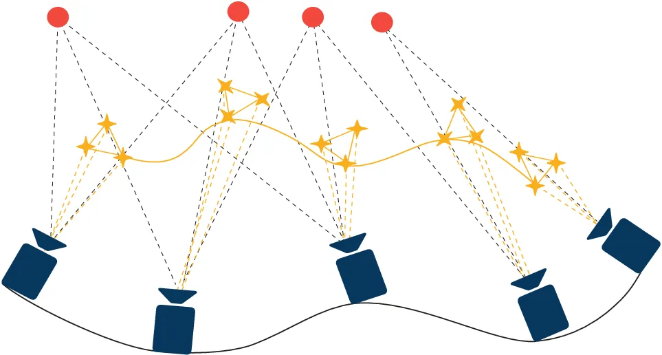
Dense mapping using a monocular camera in outdoor environments presents unique challenges and opportunities [17], [18], [19], [20], [21], [22]. These systems are lightweight and cost-effective compared to multi-camera setups, relying solely on visual information to estimate both the camera trajectory and the structure of the surrounding environment. For instance, Ling et al. demonstrate a probabilistic approach to dense reconstruction from a moving monocular camera, adaptable to various depth ranges in both indoor and outdoor settings [23]. Additionally, Dai et al. [24] provide a representative illustration of monocular feature tracking across sequential camera poses, where visual landmarks are observed over time to reconstruct the camera trajectory and estimate scene geometry. Their framework emphasizes the propagation of visual features across frames to maintain consistency in motion estimation, as shown in Fig. 2, highlighting how feature-based methods depend on robust correspondence tracking between successive images to infer depth and motion.
However, monocular systems face significant limitations due to the lack of direct depth measurement, unlike stereo systems that triangulate depth using two cameras. This absence of depth leads to scale drift, where the perceived scale of the environment varies over time, causing inaccuracies in the generated map [25], [26]. Errors in trajectory estimation accumulate, leading to localization drift and degraded map reliability [27], [28]. Without knowledge of an absolute baseline, the scale of a monocular map is subject to catastrophic drift, which can severely undermine the utility of the mapping process [29]. To address this, monocular systems are often fused with inertial sensors (IMUs) [30] or global navigation systems (GNSS) [31] to provide scale information and improve robustness.
Recent work has focused on addressing the limitations of monocular depth estimation through advanced computational methods and deep learning techniques. For instance, Convolutional Neural Network (CNN)-SLAM employs learned depth prediction to enable real-time dense mapping, effectively reducing scale ambiguity [32]. Other methods, such as Structure From Motion (SfM) [33] and motion-based parallax [34], infer depth by analyzing sequential frames, but they are susceptible to computational cost and estimation errors, particularly over longer distances. Multitask networks have also been proposed to jointly extract geometric and semantic information from monocular images, improving scene understanding for outdoor semantic mapping, an essential capability for autonomous navigation [35]. These learning-based approaches leverage high-resolution visual input to estimate scene geometry, even in complex and dynamic environments. Nevertheless, their performance deteriorates in low-light, feature-sparse, or adverse weather conditions, where depth estimation becomes unreliable due to insufficient visual cues [34].
2.1.2 Binocular camera (Stereo camera)
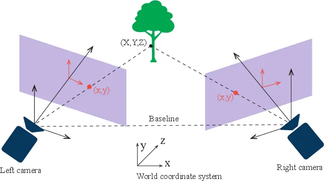
Stereo vision systems utilize two or more cameras to simulate human binocular vision, allowing for the extraction of 3D spatial information from 2D images. The use of binocular cameras, or stereo cameras, for mapping applications has gained significant traction due to their ability to effectively capture depth information for near and far objects [36]. One of the primary advantages of stereo cameras is their ability to generate accurate depth maps through triangulation as illustrated in Fig. 3. The disparity between images captured from slightly different viewpoints enables the calculation of depth information, which is crucial to creating detailed 3D maps [37]. In this case, the calibration and synchronization of stereo camera systems are critical for achieving high-quality mapping results. Precise calibration ensures that the geometric parameters of the cameras are accurately defined, which is essential for minimizing errors in depth estimation. The synchronization of image capture between cameras is equally important, as any discrepancies can lead to significant inaccuracies in the resulting 3D maps [38], [39].
A dual-camera system with a known baseline that captures two distinct views remains a cost-effective alternative to LiDAR, as it provides authentic depth perception through triangulation. By leveraging parallax between the two images, this configuration yields a dense disparity (depth) map of the scene, thereby enabling 3D perception of surrounding environments. As depth is computed directly, stereo vision generally surpasses monocular approaches in accuracy; however, depth precision degrades quadratically with increasing distance because the disparity signal diminishes significantly for objects located farther away [40]. Consequently, the effective sensing range of a stereo system is typically constrained by the baseline and camera resolution, and employing a sufficiently wide baseline for long-range depth sensing may be infeasible on smaller robotic platforms [41]. Despite the ability to generate high-resolution dense depth outputs comparable to lower-end LiDAR, the computation of dense stereo correspondence is often intensive, although real-time performance can be achieved through optimized algorithms and dedicated hardware [41]. Stereo accuracy and resolution are further dependent on lighting conditions and surface texture; low-texture or reflective materials can cause correspondence failures. In addition, any misalignment or instability in the calibration of the two cameras adversely affects the depth accuracy [42].
Visual-only mapping is greatly affected by lighting conditions, with poor performance in high exposure or low light. The system will lose tracking when the camera moves too fast, rotates abruptly, or operates in large open spaces such as crop fields and forests. As a result, the system cannot match anchor visual features on the temporal clue when the camera rotation angle is too large, causing the tracking to fail [36], [37], [43]. Additionally, repetitive textures in crop fields can cause visual measurement uncertainties and distance estimation errors. Real-time performance requires embedded computing platforms [44].
2.1.3 RGB-Depth camera (Structural light systems)
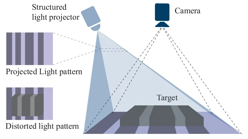
RGB-D cameras have emerged as a pivotal technology in dense mapping for mobile robots, leveraging their ability to capture both color (RGB) and depth information simultaneously. The operation of RGB-D cameras is fundamentally based on structured light as shown in Fig. 4 or time-of-flight principles, which allow them to generate depth maps by measuring the distance to objects in the environment. This dual capability facilitates the creation of dense 3D point clouds, which are essential for various applications, such as 3D mapping of the environment [45]. In [46] RGB-D cameras provide both color and depth information, enabling a more detailed understanding of the environment compared to traditional RGB cameras alone. [47] Their relatively low cost and compact size make them accessible for a wide range of robotic applications [48]. Furthermore, RGB-D cameras are less sensitive to lighting variations compared to traditional RGB cameras, which is particularly beneficial in indoor settings where lighting conditions can change rapidly [49], [50]. The ability to generate high-resolution depth maps at real-time frame rates (e.g., 30 Hz) also supports dynamic scene analysis, enabling robots to adapt to moving objects and changing environments [51], [52].
However, RGB-D cameras also face several limitations. One significant challenge is their range limitation, typically effective only within a few meters, which can hinder performance in larger environments [53]. Additionally, depth data can be compromised by reflective or transparent surfaces, leading to inaccuracies in the generated depth maps. The quality of the depth information is also affected by noise and occlusions, particularly in cluttered environments, which can complicate the mapping process [54], [55]. RGB-D cameras that use structured light technology perform poorly outdoors. Although RGB-D sensors based on IR time of flight (ToF) perform somewhat better, they remain vulnerable to sunlight interference, are affected by vegetation’s absorption of short-wave infrared and have a limited operational range. In contrast, stereo vision–based devices are largely immune to these issues, though they come with their own limitations. [56], [57]. These devices are generally available at moderate cost and are readily incorporated into robotic platforms, making them popular for mapping applications. By generating dense depth maps at video frame rates (e.g., 30Hz), these sensors markedly simplify three-dimensional (3D) mapping tasks. Their operational range, however, is typically limited to less than 10 meters for structured light systems [58], which is sufficient for most indoor settings but proves inadequate for large-scale outdoor mapping [58]. Depth accuracy is high at shorter distances, ranging from millimeters to a few centimeters of error, although it diminishes noticeably with increased distance [59]. For instance, a depth error of approximately 5 centimeters at a range of 4 meters has been reported for the Kinect sensor [58]. In addition, the depth images typically feature lower spatial resolution than the corresponding RGB images, and they may exhibit substantial noise. On the other hand, their computational requirements are modest [60], given that depth calculation is performed on-board the sensor; real-time, dense 3D mapping is thus constrained primarily by data transfer (e.g., via USB) and frame rate rather than by processing overhead. While such sensors function reliably in controlled spaces, transparent, reflective, or highly absorptive surfaces can lead to missing or noisy data. Finally, these sensors exhibit limited adaptability to weather conditions (for example, rain or fog), rendering them optimal for indoor or low light scenarios that do not introduce significant IR scattering [61].
2.1.4 mmWave Radar
Millimeter-wave (mmWave) radar technology has emerged as a significant tool for dense mapping in mobile robotics, primarily due to its ability to operate effectively in various environmental conditions where traditional optical sensors may fail [62]. The fundamental working principle of mmWave radar involves the use of frequency-modulated continuous wave (FMCW) signals to detect objects and measure their distance and speed through the analysis of reflected signals. This technology allows for the generation of spatial maps by capturing detailed information about the environment, even in low visibility conditions such as fog, rain, or darkness [34], [63], [64], [65], [66]. The integration of mmWave radar with advanced signal processing techniques, such as multiple-input multiple-output (MIMO) systems, enhances its capability to create dense maps by improving target detection and tracking accuracy [67]. Furthermore, the technology supports high-resolution imaging and can effectively differentiate between static and dynamic objects, thereby improving the accuracy of mapping and navigation tasks [68].
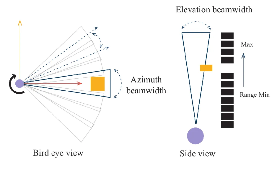
However, mmWave radar also has limitations that must be considered. One significant drawback is its susceptibility to signal attenuation due to obstacles, which can lead to reduced detection range and accuracy in cluttered environments [69]. Additionally, while mmWave radar can provide spatial information, it may struggle with the resolution of fine details compared to optical imaging systems as shown in Fig. 5, particularly in scenarios requiring high-definition mapping [70]. The complexity of processing the radar signals and the need for convoluted algorithms to interpret the data can also pose challenges, particularly in real-time applications where computational resources are limited [71]. Finally, the high frequency of mmWave signals can lead to increased sensitivity to environmental factors such as humidity and rain, which can further complicate data acquisition and interpretation [72]. Despite producing relatively sparse point clouds or range-Doppler data, millimeter-wave radar is notably robust in adverse conditions, enabling reliable operation in environments featuring smoke, fog, or precipitation scenarios. Its effective penetration of dust, darkness, and inclement weather arises because radio waves exhibit minimal sensitivity to these factors [65].
Typical sensing ranges can span from tens of meters to over 100 meters, with range accuracy often within a few centimeters through time-of-flight measurement. Nevertheless, the angular resolution and point density are significantly lower than those of optical sensors: a single-chip millimeter-wave radar may generate point clouds containing two orders of magnitude fewer points than a LiDAR system [34]. As a result, the resulting maps are substantially sparser, hindering the representation of detailed object geometries and the discrimination of adjacent features. Localization accuracy also suffers because radars, such as 77GHz units, typically have angular resolutions on the order of several degrees. On a computational level, radar signal processing, commonly relying on Fast Fourier Transforms (FFTs), is relatively lightweight and conducive to real-time execution on specialized hardware, and the data output rate is comparatively low. While real-time mapping is attainable, advanced algorithms (e.g., occupancy grid mapping or sensor fusion) are often required to interpret the sparse reflections. In addition, limitations include a propensity toward speckle noise and false positives, often induced by metallic objects or multi-path reflections [65], and difficulties in distinguishing stationary objects.
2.1.5 LiDAR (Light Detection And Ranging)
LiDAR sensors have become integral to dense mapping in mobile robotics, providing precise spatial data through the emission of laser pulses and the measurement of their reflections. These sensors generate point clouds that represent the surrounding environment in three dimensions, enabling robots to perform tasks such as obstacle detection, navigation, and mapping with high accuracy [74], [75].
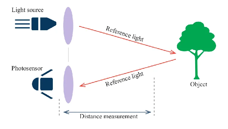
The operation of most LiDARs involves the time-of-flight principle, where the time taken for the laser pulse to return is used to calculate distances as shown in Fig. 6, resulting in a detailed representation of the environment [76]. This capability is particularly beneficial in applications requiring high-accuracy and real-time data processing, such as autonomous vehicles and robotic navigation systems [77]. Another type of LIDARs are known as, Amplitude-Modulated Continuous-Wave (AMCW) systems. This type of LIDAR steers a laser beam, whose intensity is sinusoidally modulated at radio frequencies, across a scene to acquire high-resolution depth measurements point by point. At each scan position, the backscattered light is compared against a reference modulation signal at multiple phase offsets, allowing the extraction of the round-trip phase delay, which directly translates to range. To overcome the inherent \(2\pi\) phase-wrapping ambiguity and extend unambiguous range, AMCW LiDARs often employ multi-frequency modulation or specialized focusing optics combined with computational disambiguation algorithms. Advanced implementations, such as digital-parallel demodulation architectures, enhance demodulation contrast and throughput, while machine-learning-based multipath-interference suppression can achieve millimeter-scale accuracy even in complex environments [78].
The advantages of LiDAR sensors include their ability to operate effectively in various lighting conditions, providing reliable data regardless of ambient light, which is a significant limitation for traditional cameras. The high spatial resolution of LiDAR data enables precise object detection and classification, making it a preferred choice for applications in autonomous driving and robotics [79], [80], [81]. Furthermore, advancements in LiDAR technology have led to the development of more compact and cost-effective sensors, broadening their accessibility for various robotic applications [82], [83]. Although LiDARs function effectively in both daylight and night time conditions, they face limitations. One significant drawback is their performance degradation in adverse weather conditions, such as heavy rain, fog, or snow, which can obscure the laser signals and affect data quality [84], [85] or airborne particulates can attenuate or scatter the laser beams [34]. Moreover, LiDAR systems can be expensive, particularly high-resolution models, which limits their adoption in cost-sensitive applications [86]. The data generated by LiDAR is often sparse, requiring sophisticated algorithms for effective processing and interpretation, which can increase computational demands [87]. Additionally, while LiDAR provides excellent distance measurements, it lacks color and texture information, which can be crucial for certain applications, necessitating the integration of other sensors, such as cameras, for enhanced perception [88], [89].
Although historically expensive, recent advances in solid-state technology and budget LiDAR models are steadily reducing costs. These devices provide high-resolution spatial data, frequently achieving centimeter-level accuracy at distances of several tens of meters [34], with some outdoor units offering measurement ranges spanning 100–200 meters (depending on sensor classification and target reflectivity). The resulting 3D point clouds exhibit dense coverage and minimal noise [41], thus capturing fine geometric details and yielding robust maps that facilitate precise localization and informed path planning. The sensor’s data output, often in the order of tens or hundreds of thousands of points per second, can necessitate significant computational resources; however, algorithms such as scan matching and iterative closest point (ICP) are typically optimized for real-time execution on onboard computing platforms. Most LiDAR systems employ rotating or scanning components at rates from approximately 5 Hz to 20 Hz (and, in some cases, higher), providing updates sufficiently frequent to enable real-time planning when combined with odometry [90].
Table 1 presents a comparative overview of key sensor modalities commonly employed in dense mapping for mobile robot motion planning, including monocular and stereo cameras, RGB-D sensors, mmWave radar, and LiDAR. Each modality is evaluated across several criteria, such as accuracy, range, computational demand, and suitability for real-time operation in unstructured environments.
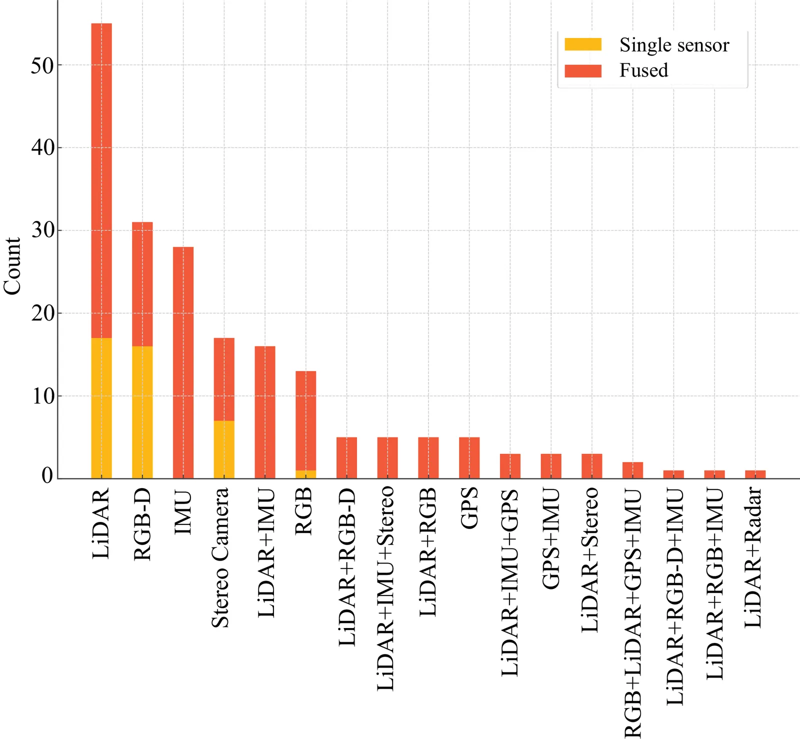
To complement this qualitative comparison, Fig. 7 provides a statistical summary of sensor usage across the studies included in our review. It illustrates the distribution of sensing configurations, whether used as standalone sensors or in fusion with other modalities.
2.2 Mapping Techniques
A comprehensive overview of state-of-the-art mapping techniques, organized according to the underlying data structures and representations they employ, is presented in this section. To better structure the review, mapping methods are divided into three main groups:
data structure for map representation
content of cells
hierarchy of maps
| Sensor | Cost | Accuracy | Resolution | Range | Comput. cost | Real-Time | Environ. | In-Depth/Technical Review |
|---|---|---|---|---|---|---|---|---|
| Mono cular Camera | Very low [34] | No direct depth; scale drift possible [34] | High 2D image resolution | Long theoretical range (but practical depth limited by features) | Moderate to high (e.g. structure-from-motion) | Challenging, but possible with SLAM optimizations [34] | Sensitive to lighting/texture; fails in darkness | Relies on motion parallax or learned models for depth; prone to drift and scale ambiguity. Good in well-lit, texture-rich scenes. |
| Stereo Camera | Moderate [33] | Direct triangulation improves accuracy vs. monocular [33], [41] | Dense disparity map (depends on baseline, camera specs) | Up to a few tens of meters (baseline-limited) | Moderate (stereo matching, rectification) | Real-time feasible with optimized matching [33] | Dependent on lighting, texture for good stereo correspondence | Generates metric mean depth; accuracy decreases at larger distances. Baseline must remain stable. Potential hardware acceleration with modern Graphics Processing Unit (GPU)s/FPGAs. |
| RGB-D Camera | Moderate | Accurate at close range; errors grow with distance | Depth resolution lower than color (e.g. \(\sim640\times480\)) | Typically \(<10\) m [58] | Low to moderate (onboard depth computation) | Easily real-time (30 FPS common) | IR-based; direct sunlight interference outdoors [58] | Structured light or ToF sensors. Ideal for indoor dense mapping [58], poor in harsh outdoor lighting or reflective surfaces. |
| mm Wave Radar | Moderate [65] | Good range accuracy; limited angular resolution | Sparse point clouds (lower density) | Tens to over 100 m [65] | Moderate (FFT-based processing [90]) | Yes, dedicated signal processors exist | Robust to fog, rain, smoke, darkness [65] | Excellent in adverse conditions. Low angular resolution requires advanced mapping/fusion. Sees through obstacles (thin walls, dust, etc.) better than optical sensors. |
| LiDAR | Historically high (decreasing) [34] | High (cm-level) [41] | High point density | Up to hundreds of meters (depending on model) | High (large data rate, but well-optimized algorithms) | Yes (5- -20 Hz scanning common) | Day/night use, performance degrades with fog/rain [34] | Gold standard for precise 3D mapping [34], [41]. Spinning parts may reduce reliability; struggles with transparent/reflective surfaces. |
The classification of mapping methods is presented in Fig. 8.
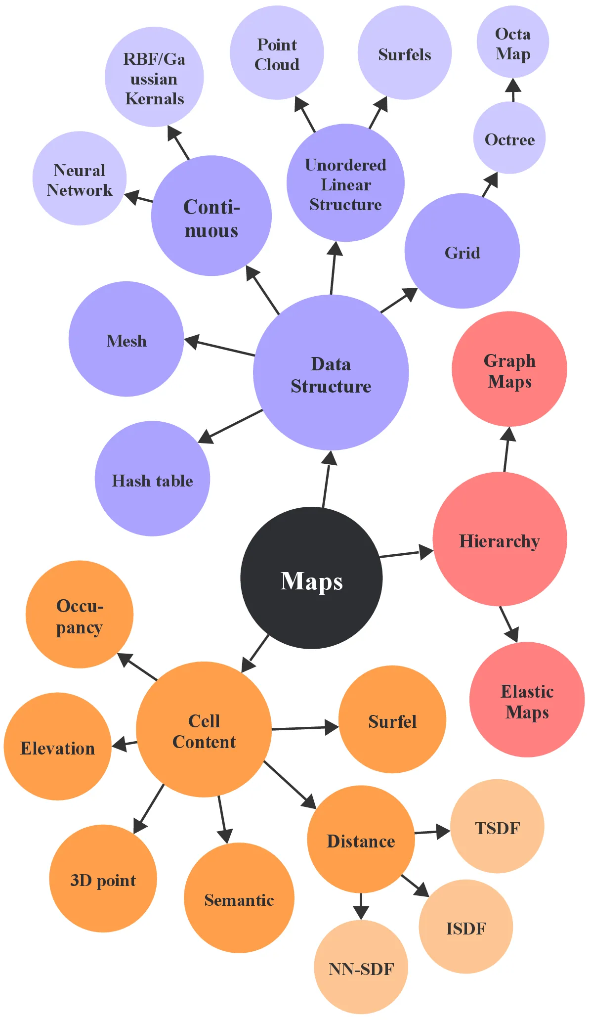
The following main data structures are identified: grid-based representations, which discretize the environment into cells; octree-based schemes (e.g., OctoMap) that adaptively partition space into hierarchical voxels; Unordered linear structures, encompassing point clouds, surfel-based models, and generic map databases that store raw measurements without explicit connectivity; Mesh-based representations, which triangulate or polygonize surfaces to capture geometric detail; and Continuous representations, such as and neural-network–driven formulations that encode maps as analytic or learned functions, Radial Basis Functions or Gaussian kernels. Mapping methods in robotics focus on more efficient data structures to represent and store information about the environment to minimize the map update and query time and maximize the accuracy of the model. Traditional approaches often rely on 2D [91] or 3D occupancy grids, which discretize space into uniform cells for straightforward probabilistic modeling, though at the cost of memory scalability in 3D. Vector maps that represent geometric primitives are excluded from this review, as they are not widely adopted or commonly applied in agricultural robotics.
Moreover, many mapping techniques that discretize space into individual cells (e.g., grid-based and octree-based representations) store a scalar or vector value in each cell, and additional subcategories of maps are defined by the nature of these stored values. For instance, when each cell is encoded with the probability of occupancy, an occupancy grid (or OctoMap-style voxel map) is produced; when the stored value corresponds to height, an elevation map is produced; when it represents the distance to the nearest surface, a Euclidean Signed Distance Field map (ESDF) or its truncated variant (TSDF) is produced; and when each cell carries a parameterization of local surface geometry (e.g., an ellipsoid), a Normal Distributions Transform occupancy map (NDT-OM) is produced. Likewise, richer primitives, such as surfels (surface elements), individual 3D points, or learned descriptors, may replace probabilistic or geometric scalars, thereby permitting dense, visually detailed reconstructions. Finally, when each cell is annotated with a semantic label (e.g., “road,” “vegetation,” “building”), the resulting structure is referred to as a semantic map. In this way, the taxonomy of mapping techniques can be further refined beyond the choice of underlying data structure by examining the quantity and semantics of what is stored per discretized element.
In addition to the data-structure and value stored, mapping methods can also be viewed hierarchically. In this framework, small local maps (e.g., Google Cartographer’s submaps [91]) are linked via pose graphs to maintain global consistency. More advanced schemes build multiple levels, such as coarse topological layers above dense metric submaps, to improve scalability and efficiency. In the subsections that follow, key papers on these categories are reviewed in turn, with their principles, strengths, limitations, and related extensions discussed.
2.2.1 Data Structures for Map Representation
Mapping algorithms depend critically on the underlying data structure, as it defines how spatial information is discretized, stored, and updated within the map. The structure fundamentally determines the balance between memory efficiency and map fidelity, two key performance criteria in robotic mapping. Memory efficiency is influenced by how sparsely or hierarchically space is represented: for instance, octrees and voxel hashing schemes minimize storage by allocating memory only to occupied or information-rich regions, while uniform grids store the entire workspace regardless of occupancy, leading to cubic memory growth with resolution. Conversely, map fidelity, the accuracy and level of geometric detail captured, depends on how finely the data structure can represent spatial variation; denser grids or continuous implicit functions yield higher fidelity but incur substantial memory and computational costs. Point-based or surfel-based models offer flexible surface representation but trade spatial completeness for efficiency. Ultimately, the choice of data structure governs both the scalability and precision of the mapping process, influencing reconstruction quality, update rate, and the computational resources required for real-time operation.
2.2.1.1 Octree
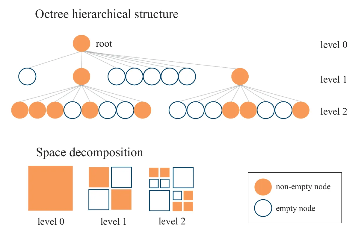
OctoMap, an octree-based structure, is a 3D occupancy grid mapping framework designed for efficient occupancy representation in volumetric space, organizing the environment into hierarchically structured voxels, as shown in Fig. 9 to achieve memory-efficient storage by pruning unoccupied regions [92], [93], [94]. Octrees offer a memory-efficient hierarchical representation that adapts to spatial occupancy and guarantees logarithmic access time. Initially, octrees were used to store occupancy probabilities; however, voxels can also store Gaussian-based models to better represent shapes within the voxel [95], or Euclidean distances [96], [97], [98], which further aid in obstacle avoidance. OctoMap incorporates probabilistic occupancy estimation, effectively addressing sensor uncertainties and dynamic scenarios. Extensions to OctoMap have facilitated semantic 3D mapping; for example, CNN-SLAM integrates CNN-derived depth predictions with monocular SLAM within an OctoMap-based framework to generate dense semantic maps [99]. Similarly, Yang et al. employ an octree-based occupancy grid enhanced with conditional random field (CRF) optimization for semantic voxel labeling [100]. Advanced octree-based variants, such as VDB-Mapping, utilize OpenVDB for efficient sparse volumetric data representation [101], while SHINE-Mapping employs hierarchical implicit neural representations embedded in octree structures, combining traditional efficiency with neural network expressiveness [94]. OctoMap’s compactness and multi-resolution mapping capabilities enable efficient storage and rapid spatial queries, making it highly suitable for large-scale environmental modeling [102].
OctoMap applications notably include UAV and underwater robotics; however, ground vehicle applications often prefer 2.5D elevation maps for their computational advantages. Nevertheless, OctoMap demonstrates notable limitations in performance relative to contemporary neural reconstruction methods; experimental comparisons indicate significantly longer processing times and a lack of semantic segmentation for traversable objects [103]. Alternative mapping strategies, such as REAL (Rapid Exploration with Active Loop-closing), which integrate frontier-based exploration, graph planning, and active loop-closure mechanisms, have demonstrated improved performance metrics over OctoMap-based methods, particularly in exploration efficiency and pose accuracy [104].
A Gaussian Process Regression (GPR) approach with a novel inverse square law-based kernel has been developed to address data sparsity and uncertainty in radiation mapping. In this work, OctoMap serves as the underlying probabilistic octree, initially constructed by the robot using LiDAR/SLAM for spatial indexing. The Gaussian Process-predicted radiation intensities are then projected into the octree’s voxels. This approach demonstrated superior predictive accuracy in scenarios involving multiple radiation sources compared to conventional techniques [105]. Further advancements include OctoMap-RT, which leverages GPU-based massively parallel ray-shooting combined with hybrid Central Processing Unit (CPU)-GPU architectures, achieving mapping speeds up to 41.2 times faster and occupancy grid accuracy improvements of 0.52% over traditional OctoMap and SuperRay methods, addressing voxel determination bottlenecks with novel voxel and Bounding Volume Hierarch (BVH) representations [106]. Other variants of tree-based data structures have also been explored. For example, Slutsky and Dobkin introduced a Dual Inverse Sensor Model (ISM)-based approach for rapid volumetric occupancy grid generation using a Quad-Tree structure in automotive applications. Their method demonstrated a 15-fold speedup in high-resolution mode and achieved real-time frame rates between 25 and 50 FPS, effectively handling simultaneous multi-sensor integration [107].
2.2.1.2 Voxel Grid
Algorithms, such as Voxblox and Nvblox, have established themselves as efficient methodologies for dense 3D reconstruction in robotics. These methods discretize space into voxels that encode occupancy or signed distance information, thereby explicitly representing free space and distinguishing between known and unknown regions [109], [110], [111], [112], [113]. Voxblox employs a CPU-based, two-level sparse voxel hashing scheme that enables real-time updates and querying of truncated signed distance fields (TSDFs) and Euclidean signed distance fields (ESDFs) [114]. Its spatially hashed voxel representation efficiently allocates memory to occupied regions, making it well suited for applications requiring both free space awareness and surface reconstruction [115], [116]. Nevertheless, CPU constraints limit the attainable map resolution and scale, particularly in high-detail or large-scale environments, and while recent optimizations such as Voxfield and FIESTA improve ESDF generation and runtime, these enhancements are bounded by the inherent computational load [117], [118]. In contrast, Nvblox leverages GPU acceleration to overcome these limitations. By parallelizing all aspects of the mapping pipeline, including real-time querying, Nvblox achieves up to 177× faster TSDF updates and 31× faster ESDF computations relative to its CPU-based counterpart, thereby facilitating high-resolution mapping on embedded GPU hardware [119], [120]. Although this approach necessitates GPU resources, the substantial performance gains enable higher update frequencies and improved map fidelity critical for dynamic robotic path planning and obstacle avoidance. Notably, as the desired resolution of the map increases, the memory requirements scale cubically, rendering the representation of large, detailed environments computationally intensive.
Another mapping algorithm based on voxelized spatial data is the Normal Distributions Transform (NDT), a probabilistic technique for point cloud alignment. NDT models the environment as a collection of Gaussian distributions, each defined by a mean and covariance, derived from voxelized spatial partitions. The alignment process seeks to maximize the likelihood of the observed points given the model distributions, mathematically expressed as:
\[E(R, t) = \sum_{i=1}^{M} \log P(P_i \mid R Q_i + t)\tag{1}\]
where \(P(P_i | R Q_i + t)\) is the conditional probability of observing point \(P_i\) given the transformed model point \(Q_i\) [121], [122]. NDT faces challenges including computational complexity due to voxelization and Gaussian fitting processes, potentially limiting real-time applications [123]. Furthermore, its performance is sensitive to parameter selection, such as voxel size and iteration count, influencing accuracy and convergence. Normal Distributions Transform Occupancy Map (NDT-OM) however, is a novel 3D mapping framework that extends traditional NDT methods by incorporating a recursive update scheme for Gaussian cell parameters alongside a probabilistic occupancy update, enabling efficient, memory-bounded, multi-resolution mapping in large-scale, dynamic environments [124].
NDT-OM is highly adaptable and remains robust against noise, even in dynamic, complex environments. Although, NDT-OM often outperforms grid-based approaches at coarser resolutions, updates can be slower than octree-based occupancy maps at equal discretization, potentially limiting its applicability in scenarios with extremely high sensor rates or very fine resolution requirements [125]. Building on NDT-OM’s adaptability and robustness, modern 3D mapping systems often pair it with high-resolution LiDAR hardware and optimized SLAM pipelines to balance accuracy and real-time performance. Multi-channel LiDAR configurations, such as Velodyne’s 16, 32, 64, and 128-channel models, significantly influence 3D mapping fidelity and computational complexity; higher channel counts yield denser and more detailed point clouds but impose increased computational demands, a sample point cloud map of the forest environment is presented in Fig. 6. Addressing these constraints, selective keyframe techniques have been proposed to facilitate real-time 3D reconstruction from high-density 128-channel LiDAR data, demonstrating superior detail and practicality for real-time applications [126]. Additionally, a novel 3D LiDAR reconstruction framework has been proposed, leveraging encoder-decoder neural networks to densify sparse LiDAR data with camera images, significantly improving free-space estimation by over 40% and effectively generalizing from synthetic to real-world conditions, enabling low-cost sensors to perform comparably with high-end LiDAR systems [127]. As an alternative to voxel grids planar-surface-based occupancy grids have also been proposed, reducing memory usage and erroneous artifacts by clustering stereo-vision point clouds into planar cells and combining them into efficient 3D representations [128].
2.2.1.3 Voxel hash
Both Voxblox and Nvblox frameworks utilize voxel hashing to manage memory efficiently in large-scale environments by allocating storage only to occupied regions, ensuring fast access times even in sparsely populated scenes [93]. This efficiency is crucial for real-time dense mapping, where prompt integration of sensor data is essential [129], [130]. Extensions of these voxel-based methods have also been developed for multi-robot systems. For instance, Coxgraph transforms ESDF submaps into compact mesh packs, enabling efficient inter-robot data transmission and supporting globally consistent dense mapping under limited bandwidth conditions [131].
2.2.1.4 Unordered linear structures
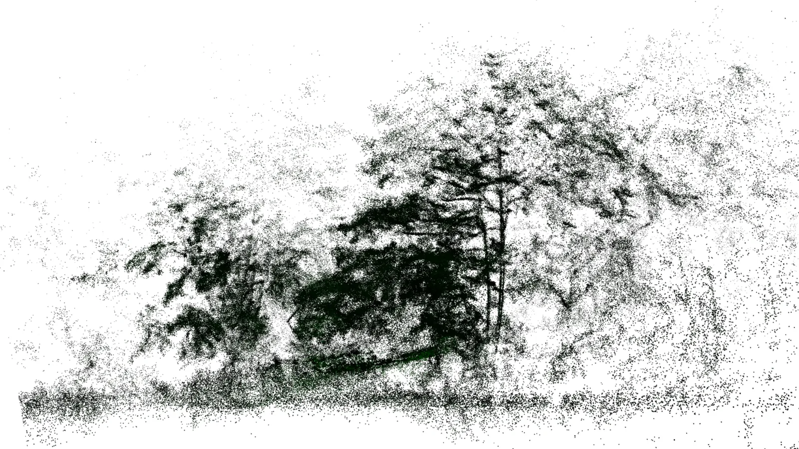
Point clouds [132], [133], [134] provide unordered sets of spatial samples, as shown in Fig. 10. This data structure is useful for visualization, but is memory inefficient and slow while querying the selected region of the model for motion planning. Alternatively, surfels (surface elements) [135] can be used to accumulate points in a geometric structure and save memory. However, this approach does not significantly improve the query time even if the K-dimensional tree is used.
RTAB-Map is a robust dense point cloud mapping algorithm for real-time 3D mapping and navigation that integrates multiple sensor modalities, including RGB-D, stereo, and LiDAR and accommodates diverse odometry inputs. The system constructs dense point-cloud maps while employing Bayesian filtering for loop closure probability estimation, ensuring high accuracy and effective long-term online operation [136], [137]. Central to its performance is a hierarchical memory management scheme that categorizes data into Short-Term Memory (STM), Working Memory (WM), and Long-Term Memory (LTM) [13]. This structure not only retains recent observations and actively processed data but also archives less frequently accessed scans to memory, thereby optimizing RAM usage. The algorithm’s incremental appearance-based loop closure detection leverages both global and local feature extraction, often enhanced by deep learning models to reliably identify previously visited locations, generate location points with time indices and image signatures, and update corresponding weights [138], [139], [140]. Such capabilities are critical in dynamic environments.
Low-cost 3D LiDAR scanners, when combined with Extended Kalman Filter models, facilitate accurate and reliable point-cloud acquisition for precision agriculture applications. In parallel, open-source handheld mobile mapping systems have emerged as a flexible alternative for large-scale 3D mapping, offering GPU-independent operation and demonstrating effectiveness in both indoor and outdoor environments [141], [142]. In addition, novel algorithms that combine stereo camera output with ultrasonic data and perception pipelines that employ deep networks for point cloud classification have automated map cleaning and enhanced segmentation accuracy, thereby improving dense mapping outputs for autonomous navigation [134]. Additional contributions include robot-assisted mobile scanning approaches that integrate SLAM with motion control and semantic segmentation to generate high-quality dense point clouds for building interiors, and semi-automatic frameworks that align SLAM outputs with public building maps to reduce cumulative pose errors in urban environments [143], [144]. Finally, integration of Inertial Navigation System (INS)/GNSS with LiDAR Odometry and Mapping (LOAM) facilitates global georeferencing of dense point clouds with meter-level accuracy in GNSS-challenged areas, while real-time incremental manifold mesh reconstruction algorithms operating on a single CPU core significantly boost computational efficiency without sacrificing reconstruction accuracy [145], [146], [147]. A feature-by-feature comparison of the main map data structures is shown in Table 2.
2.2.2 Cell-Content-Based Map Representations
In discretized mapping, the cell content is as crucial as the data structure itself. Cells might hold occupancy probabilities for collision checking, height values for terrain models, or signed-distance measures for surface reconstruction. Some methods embed local surface parameters (e.g., ellipsoids or surfel normals) for high-fidelity rendering, while semantic maps assign categorical labels (e.g., “road,” “building”) to support task-driven reasoning. Crucially, what is stored per cell directly governs real-time performance: heavier cell payloads (e.g., full covariance, surfel attributes, semantics) increase memory traffic and cache misses, slowing integrations and queries; lighter payloads (e.g., binary occupancy or truncated distances) improve update rates and enable higher map resolution at the same compute budget. ESDF and TSDF cells differ in update complexity (global distance transforms vs. truncated local fusion), which sets the achievable frame rate and latency of planning queries. In this subsection, these cell-content variants and their impact on map performance and applications were examined. We emphasize the compute–fidelity trade-off: designs that favor minimal per-cell state and locality-friendly updates tend to meet hard real-time budgets, whereas richer per-cell representations improve map fidelity but require GPU acceleration, asynchronous pipelines, or aggressive sparsification to remain real-time.
Building on cell content representations, metric maps are those in which each cell stores a numerical metric quantifying a local property of the environment e.g., distance to the nearest surface, height above a reference plane, or probability of occupancy. Where each voxel or grid cell holds a scalar (or small vector) that captures crucial information for navigation, perception, or planning. Real-time behavior depends on both the arithmetic cost of updating that metric and the spatial footprint touched per sensor ray; algorithms that confine updates to a local band around surfaces (e.g., TSDF) or use incremental distance maintenance (fast ESDF variants) typically sustain higher Hz than global recomputation.
Various methodologies exist for their generation, including Continuous-space Mapping and Volumetric Mapping Algorithms. Continuous-space mapping entails representing an environment with continuously varying position and orientation parameters, a characteristic that is indispensable in applications requiring high precision and smooth navigational trajectories. This approach is typically integrated with high-density sensor data, thereby allowing for fine-grained adjustments and real-time map updates.
Conversely, volumetric mapping algorithms focus on constructing three-dimensional representations by modeling the spatial volume. In these methods, the environment is discretized into volumetric elements, or voxels, each capable of storing information such as occupancy, color, and texture. Per-cell content determines whether updates are parallel (well suited to GPU) or require neighborhood dependencies (e.g., ESDF propagation), which affects achievable throughput and update latency. This section further examines several pivotal metric-mapping techniques, all variants of Euclidean Distance Fields (EDF), namely Euclidean Signed Distance Functions (ESDF), Truncated Signed Distance Functions (TSDF), and Implicit Signed Distance Functions (ISDF).
2.2.2.1 Euclidean Distance Fields (ESDFs)
provide a mathematical representation of shapes by assigning each point in space a scalar value corresponding to its shortest distance to the surface of the shape. In ESDF mapping, this principle is employed to record the signed distance at every spatial point, using a convention where the distances are positive for the points outside the shape and negative for the points inside it. \[\phi(\mathbf{x})
=
\operatorname{sgn}\bigl(o(\mathbf{x})\bigr)\;\min_{\mathbf{y}\in\partial O}\|\mathbf{x}-\mathbf{y}\|
\quad\tag{2}\] where \[o(\mathbf{x}) =
\begin{cases}
+1, & \mathbf{x}\notin O\quad(\text{free space}),\\
-1, & \mathbf{x}\in O\quad(\text{inside obstacle})
\end{cases}\tag{3}\]
and \(\partial O\) is the obstacle boundary [97]. In practice, these functions are commonly implemented via voxel grids that discretize the three-dimensional space, with each voxel encapsulating the signed distance value. As new depth measurements are acquired from sensors such as LiDAR or RGB-D cameras, the ESDF is incrementally refined to enhance the fidelity of the reconstructed map. ESDF computes the precise Euclidean distance from each 3D point to the nearest surface, delivering metric fields essential for accurate motion planning and collision avoidance. ESDFs require a complete geometric reconstruction of the environment, incurring significantly higher computational overhead. The processing cost scales directly with voxel resolution; finer discretizations improve metric precision, but require increased computational resources and memory [148]. Although incremental algorithms can mitigate some of these challenges, real-time generation of high-resolution ESDF maps in large-scale environments remains a nontrivial problem. An alternative and promising avenue is the use of neural networks to implicitly represent ESDFs. These neural ESDF frameworks have the potential to offer more compact storage solutions and improved generalization to unobserved areas [149], [150], [151].
Despite these advancements, several limitations persist. One significant issue is the approximation error incurred when integrating new measurements. Many implementations rely on projective distances along sensor rays for ESDF updates, a method that can result in inaccuracies, particularly for surfaces viewed at oblique angles [152].
| Feature | Grid-based | Octree-based | Unordered | Mesh-based | Continuous |
|---|---|---|---|---|---|
| Spatial structure | Uniform cells | Hierarchical voxels | Points / Surfels | Triangles / Polygons | Implicit function |
| Occupancy modeling | Yes | Yes | No | No | No |
| Distance-field support | TSDF / ESDF | Extensions (TSDF/ESDF) | No | No | SDF |
| Multi-resolution | No | Yes | No | No | Yes |
| Semantic mapping | Yes (semantic grid) | Yes (CRF/CNN-SLAM) | Yes (point labels) | Limited | No |
| Real-time updates | Yes (CPU) | Yes (CPU) | Yes | Limited (batch rebuild) | No |
| Memory efficiency | Low | High | Medium | Medium | High |
| Planning support | Yes | Yes | Limited | Yes | Yes |
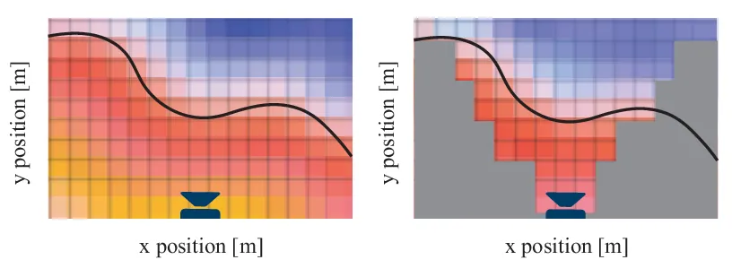
To counteract this, some researchers have proposed normal-guided sampling techniques that compute distances along the surface normals rather than along the sensor rays as shown in Fig. 11. Additionally, the computational cost associated with high-resolution voxel data access and map updates can become a bottleneck for real-time applications, prompting further research into hardware acceleration and more efficient data structures [93]. For neural ESDF representations, the issue of catastrophic forgetting during incremental mapping remains a concern; as neural networks update with new observations, there is a risk of losing information from previously mapped regions. Techniques such as robot-centric mapping and bundle supervision have been proposed to mitigate this problem by maintaining an accurate local map and constraining network training with historical data [153].
2.2.2.2 Truncated Signed Distance Function (TSDF)
Truncated Signed Distance Functions (TSDFs) extend the conventional ESDF approach by truncating distance values beyond a predefined threshold. This modification yields a more tractable representation of the environment, particularly in real-time applications, by preserving the smooth surface characteristics of ESDFs while reducing both memory footprint and computational overhead. However, TSDFs exhibit limitations, notably in their diminished capacity to represent distant points accurately, which can lead to drift in tracking scenarios. Moreover, the resolution constraints inherent to TSDF representations may impair data association during depth image processing, especially when utilizing high-resolution sensors [154].
A principal advantage of TSDFs lies in their ability to produce high-quality, smooth surface reconstructions [110]. This is typically achieved through trilinear interpolation methods during surface extraction, often implemented via the Marching Cubes algorithm. The zero-crossing of the signed distance field accurately delineates surface boundaries, facilitating the extraction of meshes or point clouds, and generally yielding three-dimensional models with superior fidelity compared to alternative mapping techniques [109], [135].
Notwithstanding these benefits, TSDF mapping faces substantial challenges in terms of memory efficiency. The storage of dense voxel grids can be prohibitively expensive for large-scale environments. To mitigate this, many implementations have adopted sparse voxel representations, such as voxel hashing, which allocate memory only to voxels proximal to observed surfaces [109]. Additionally, the truncation process itself may impede the accurate representation of thin structures that are smaller than the truncation threshold, potentially resulting in a loss of fine geometric detail.
Despite these limitations, TSDF mapping remains a widely adopted and effective approach for three-dimensional reconstruction in applications that demand real-time performance and high-quality surface detail. Its robustness has been demonstrated in various domains, ranging from autonomous navigation to augmented reality. Recent research efforts have further enhanced TSDF capabilities by integrating semantic information into the mapping process, thereby enriching environmental representations with contextual understanding [155].
Real-time TSDF implementations often leverage GPU acceleration to address the computational demands associated with updating large voxel grids. For instance, the KinectFusion [156] algorithm showcased the feasibility of real-time, GPU-accelerated TSDF mapping for three-dimensional reconstruction. More recent frameworks, such as Voxblox [96], have improved both efficiency and scalability by incrementally constructing the TSDF and dynamically expanding the map without prior knowledge of the dimensions of the environment [157].
Finally, TSDF mapping exhibits challenges when applied to dynamic environments. The presence of moving objects can introduce persistent artifacts in the reconstructed model, and while techniques like ray tracing have been proposed to mitigate this issue, they typically incur additional computational costs. Furthermore, TSDFs have occasionally been observed to overestimate Euclidean distances, which may further impact the accuracy of the mapping process [102], [158].
2.2.2.3 Fast Iterative Euclidean Signed Distance Transform Algorithm (FIESTA)
Computes ESDFs to rapidly determine obstacle proximities, enabling efficient, real-time map generation in cluttered environments. The algorithm’s iterative framework continuously refines the ESDF, enhancing spatial accuracy while accommodating environmental changes. However, its performance is contingent on high-quality input data; noisy or incomplete measurements can propagate errors, and its static environment optimization limits effectiveness in highly dynamic scenes. This requires the integration of auxiliary modules (e.g. semantic segmentation, dynamic object tracking) to increase robustness [97].
FIESTA consists of two core components: a feature extraction module and a tracking module. The feature extraction stage employs a multilayer FEAST network, comprising a Fast Adapting Network (FAN) and a Slow Adapting Network (SAN) arranged in a feedforward configuration, to isolate and consolidate salient events from the data stream, effectively filtering out noise. Subsequently, a modified asynchronous Probabilistic Data Association (PDA) tracker processes these events, achieving sub-pixel localization with processing times below 40 \(\mu\)s. Although the unsupervised learning strategy facilitates rapid adaptation to new targets with minimal prior modeling, the current reliance on a point target model constrains its applicability to extended or high-intensity targets. Moreover, while performance has been validated in single-target tracking scenarios, the algorithm’s scalability to multi-target environments and its behavior under low-motion, low-contrast conditions (e.g., geostationary orbits in leap-frog observations) remain open challenges [159].
2.2.2.4 Implicit Signed Distance Functions (ISDFs)
integrate neural implicit representations with traditional SDF frameworks to model complex, dynamic surfaces under noisy conditions. In ISDF, a multi-layer perceptron (MLP) maps 3D coordinates to signed distance values. The network is trained in real time using a self-supervised loss that constrains the predicted distance by the minimum distance from a batch of query points. Active sampling from a sparse set of keyframes is employed to counteract catastrophic forgetting, while batch sampling along back-projected rays enables simultaneous supervision of the signed distance and its spatial gradient.
The approach provides adaptive resolution and effective denoising through a neural field that dynamically allocates memory based on local data density. However, its implementation introduces significant complexity. The use of low-frequency positional embeddings, optimized for free, space SDFs can oversmooth surfaces, and the regularized enforcement of the Eikonal constraint inadequately handles singularities, limiting the method to room-scale environments [149].
In comparison to other SDF variants, ISDFs offer enhanced flexibility and adaptability at the cost of increased algorithmic complexity. Alternative strategies include Gaussian Process Distance Fields (GPDF) for probabilistic, continuous representations [158], and data structures such as octrees [160] and VDB for efficient memory and query performance. Multi-resolution and submap-based techniques further address scalability in large environments [118], [161].
Recent developments, such as the AiSDF framework, leverage the Atlanta World assumption to process streams of posed depth images. AiSDF achieves superior mesh reconstruction quality compared to methods like Voxblox and ISDF, generating an explicit 3D planar map composed of Atlanta-aware surfels for downstream processing [162]. However, per-keyframe surfel extraction precludes the formation of a unified global map, and integration of Atlanta priors into the implicit representation remains an open challenge.
DeepSDF mapping algorithms leverage neural network architectures to parameterize signed distance functions over 3D space. These methods employ CNNs or MLPs to extract hierarchical features directly from raw sensor data, facilitating robust reconstruction and shape completion by inferring missing regions based on learned latent representations [150], [151]. However, the training and inferencing process for these high-dimensional models is computationally intensive, often necessitating extended training periods and high-performance computing resources [163]. Moreover, while deep SDFs generalize over diverse shape classes, they may exhibit degraded performance on highly intricate geometries, leading to representation inaccuracies. The requirement for large, annotated datasets further constrains their applicability in domains where data acquisition is challenging [164].
Recent advances in 3D LiDAR mapping have increasingly leveraged implicit neural representations combined with spatial hashing and submapping techniques to achieve high-fidelity, scalable reconstructions while dramatically reducing memory consumption. These approaches converge to deliver robust dense mapping, precise localization, and improved semantic segmentation in diverse environments. A notable contribution in this domain is the introduction of compact map representations, exemplified by the Tri-Pyramid method, which significantly reduces memory requirements without compromising mapping quality. Using an implicit neural framework, the Tri-Pyramid scales seamlessly from room-scale to city-scale environments while providing localization performance on par with state-of-the-art systems [165]. Building on this, the integration of hierarchical hash encoders with spatial hash grids has further optimized the implicit mapping process. This approach not only minimizes memory overhead by mitigating hash collisions but also enhances reconstruction accuracy through real-time, accurate signed distance function (SDF) labeling. As a result, these methods achieve state-of-the-art 3D mapping performance using less than half the memory compared to previous techniques [166]. Complementing these implicit representations, the Voxgraph framework introduces a submap-based strategy for volumetric mapping. By partitioning the environment into overlapping SDF submaps and maintaining global consistency through optimal alignment, Voxgraph operates efficiently even on computationally constrained platforms. Its performance is underscored by trajectory RMSEs of less than 1 m over extensive paths, thereby outperforming traditional visual SLAM and LiDAR systems in challenging real-world scenarios [118]. Finally, advances in domain transfer for semantic segmentation have further broadened the applicability of these mapping systems. By generating semi-synthetic scans from source datasets, recent methods enable deep learning models to generalize across various LiDAR sensor configurations without the need for additional labeled data. This strategy effectively bridges domain gaps, significantly improving segmentation performance, and facilitating dense semantic annotation propagation [167].
NeuralBlox advances volumetric mapping robustness through incremental neural implicit updates from partial sequential observations, outperforming traditional TSDF methods in handling pose estimation errors and sensor noise. This approach supports real-time execution on CPUs, exhibits flexibility with diverse sensor inputs without retraining, and substantially enhances scene completeness and recall, facilitating safer robotic operation in dynamic environments [168]. Complementing this, the Depth-Visual-Inertial (DVI) mapping system integrates time-of-flight, RGB cameras, and IMU data through an error-state iterative Kalman filter, demonstrating exceptional precision and trajectory estimation robustness under complex, real-world conditions, particularly validated through the Bunker DVI Dataset [169]. Other neural models such as Neural Radiation fields (NeRFs) [170] are also still limited to small areas.
2.2.2.5 Semantic Mapping
Semantic Fusion leverages ElasticFusion for precise camera pose estimation and globally consistent surfel-based 3D reconstruction of environments [171]. It integrates CNN-based semantic segmentation on RGB-D frames to assign pixel-level class labels that are aggregated onto surfels via a Bayesian update scheme. A moving average continuously refines the semantic labels, while the inclusion of a CRF model enforces spatial regularity, which is essential for complex indoor settings. Real-time performance ensures robust pose estimation and mapping in dynamic scenarios, yet limitations persist in distinguishing individual instances within the same category [172]. Moreover, CNN dependency may compromise performance in cluttered or occluded environments [173], and high computational demands can restrict deployment [174].
Complementary to SemanticFusion, SemSegMap extends the SegMap framework by incorporating semantic and color information from RGB cameras into LiDAR-based mapping. This early sensor fusion enriches point clouds with geometric, visual, and semantic cues, enhancing segmentation consistency through an adapted Euclidean distance metric and a PointNet++-based descriptor network [175]. The multi-modal approach not only improves localization accuracy and robustness under varying environmental conditions but also facilitates detailed 3D reconstruction and semantic extraction [176]. In parallel, complementary approaches such as Volume-DROID, which integrates volumetric mapping with DROID-SLAM through real-time fusion of point cloud registration, semantic segmentation, and Convolutional Bayesian Kernel Inference, demonstrate the efficacy of dense representations in enhancing 3D semantic mapping for autonomous navigation [177]. Table 3 compares these different cell-content variants.
2.2.3 Hierarchical Map Representations
Hierarchical map representations break environments into locally consistent submaps linked by a pose graph, ensuring global coherence and efficient loop closure. Systems like Google Cartographer and Hector SLAM build local occupancy grids or point clouds and fuse them into a growing graph, correcting drift as new data arrive. Beyond simple pose-graph fusion, multi-layer hierarchies can range from fine-grained maps for real-time navigation to coarse maps for global planning, with extensions such as multi-resolution octrees or semantic annotations. In this subsection, the construction of these hierarchies, the enablement of robust mapping by pose graphs, and the variations that enhance scalability and semantics will be explored.
2.2.3.1 Graph-based mapping
methods have gained prominence due to their ability to efficiently represent and optimize robot trajectories and environment structures. The ART-SLAM [178] employs a pose graph framework, with robot poses as nodes interconnected by edges representing spatial constraints derived from sensor measurements or environmental elements such as floor coefficients. This system integrates diverse constraint information, including odometry, sensor alignment, and loop closures, using the g2o framework to achieve optimized trajectory estimations capable of handling extensive datasets like KITTI and underground mine scenarios, demonstrating both accuracy and real-time performance. Addressing scalability in graph-based SLAM, the c-blox system developed by Millane et al. [109] utilizes overlapping TSDF subvolumes for environmental representation. Camera tracking and bundle adjustment localize these subvolumes, with global trajectory optimization managed via pose graph optimization [109]. The method proposed in [179] utilizes local NDT-OM maps connected with pose graph that are optimized after loop closure detection to improve the global map. Similarly, the D3VIL-SLAM system by Frosi and Matteucci integrates LiDAR, visual, and inertial sensor data within a factor graph optimization framework, combining LiDAR localization, trajectory loop closure, and inter-frame constraints to enhance robustness [180]. Hierarchical approaches combining deep learning and graph optimization have been proposed in visual-LiDAR SLAM, incorporating modules for odometry, loop closure detection, and 3D mapping, further optimized through g2o [181]. RGB-D SLAM frameworks similarly leverage frontier-based exploration and pose graph optimization, refining trajectories through strategically selected exploration goals [182]. Continuous-time SLAM methods, particularly suitable for aerial mapping, represent trajectories as continuous temporal functions optimized via robust iterative least squares methods, incorporating sensor data, inertial measurements, and motion models for global consistency [183]. Graph-based methods further enhance mapping through explicit modeling of spatial correlations, as demonstrated by MRFMap’s use of Markov Random Fields and loopy belief propagation to address occlusions and noisy sensor data [184]. Multi-robot collaborative mapping is efficiently handled by systems like Coxgraph, achieving global consistency through joint trajectory and submap optimization across multiple agents [131]. Similarly, CAOM utilizes dense pose graph structures and factor graphs integrating local coherence and heterogeneous sensor fusion to mitigate drift [132]. In exploration contexts, methods like Volume-DROID utilize factor graphs for fusing LiDAR and inertial data, applying improved loop closure detection algorithms inspired by Cartographer to mitigate drift in trajectory estimates [177]. Systems employing multi-layered graph representations further demonstrate efficiency by combining XML-based metadata structures and optimized point cloud storage, facilitating large-scale dataset management [185].
Recent advances in graph-based mapping have yielded significant improvements across diverse applications. Deep learning applied to ground-based LiDAR point clouds now surpasses traditional methods in semantic segmentation, individual tree delineation, and species classification, although standardization and data sharing remain critical issues with emerging opportunities in Graph Neural Networks [133]. In urban navigation, novel techniques summarize large-scale 3D maps by leveraging augmented spherical RGB-D images that integrate geometric, photometric, and semantic data to construct navigability graphs, thus achieving efficient data compression without sacrificing localization performance [186]. Complementarily, graph-based SLAM approaches have been developed that obviate the need for odometry by employing scan matching and weighted motion averaging to optimize pose graphs, thereby producing robust, consistent 3D reconstructions of outdoor environments [187]. Further, innovative map merging strategies utilize deformable pose graph models to correct distortions inherent in SLAM-generated maps, enhancing global consistency and reducing cumulative errors [188]. Additionally, mesh optimization algorithms based on region-growing techniques have been shown to reduce polygon complexity by up to 75% in planar environments without significant loss of geometric precision, despite limited effectiveness for curved surfaces [189]. Finally, mapping systems tailored for non-uniform density 3D point clouds acquired by micro aerial vehicles integrate an extended Generalized-ICP algorithm with multi-edge pose graph optimization, effectively compensating for sparse data and yielding globally consistent maps [190].
RTAB-Map’s graph-based mapping framework underpins its scalability and efficiency, facilitating incremental data integration essential for large-scale applications [191], [192]. However, the memory management strategy can incur potential data loss in environments that undergo substantial changes [139], [193], and high levels of dynamic objects can challenge its loop closure detection, resulting in mapping inaccuracies [194]. Additionally, the considerable computational resources required may restrict its deployment in resource-constrained systems [136], [195]. Complementing this, approaches based on handheld LiDAR SLAM integrated within a factor graph framework have demonstrated centimeter-level mapping accuracy and efficient 3D reconstruction through LiDAR point cloud fusion, even under GNSS constraints [196].
The Robot-centric Implicit Mapping (RIM) method addresses efficiency and memory constraints in large-scale dense mapping by utilizing a hybrid representation comprising implicit features and shallow MLP networks. RIM maintains both local and scalable global maps, effectively mitigating catastrophic forgetting and handling noisy inputs via robust outlier removal, resulting in superior performance metrics, such as improved accuracy, completeness, and adaptability across extensive spatial scales [153].
The hierarchical SLAM method by Estrada, Neira, and Tardós presents a two-level mapping architecture in which independent local stochastic maps are maintained in constant time, while a sparse global adjacency graph encodes inter-map relations and enables a near-optimal, loop-closing optimization whose cost scales linearly with loop size [197]. In contrast, Folkesson and Christensen’s graphical SLAM formulates the entire mapping problem as energy minimization on a pose–feature graph, using nonlinear energy nodes and coarse-to-fine fitting to impose multiple loop constraints automatically, thereby reducing linearization errors and achieving scalable, consistent map building. Together, these approaches demonstrate that choosing an appropriate map data structure, whether a hierarchical submap graph or a globally optimized pose graph, is critical for balancing SLAM accuracy, robustness, and real-time performance [198].
2.2.3.2 Dense Object Nets (DON)
Employs deep learning architectures, predominantly convolutional neural networks, to derive dense object representations from visual data, extracting features that yield comprehensive spatial maps of object presence, arrangement, and interrelationships. This process is enhanced through instance segmentation, enabling the differentiation of overlapping instances via mask prediction and bounding box regression [199], [200], [201], while integrated attention mechanisms further refine detection by emphasizing pertinent features amid background noise [202].
The resulting dense representations provide superior environmental context compared to traditional sparse methods, facilitating accurate object localization and recognition in applications such as autonomous driving and robotic manipulation. However, the inherent computational complexity of processing dense maps can induce latency in object-dense scenarios, and reliance on extensive annotated datasets can impede generalization in novel environments [203].
| Map Type | Cell Content | Update Method | Memory Usage | Use Case |
|---|---|---|---|---|
| Occupancy Grid | Probability of occupancy | Bayesian update | Medium | Collision checking and motion planning |
| Elevation Map | Height value | Layered fusion | Medium | Terrain modeling, motion planning |
| ESDF | Signed Euclidean distance | Wavefront / BFS | High | Motion planning |
| TSDF | Truncated distance to surface | Ray-based fusion | Medium | Surface reconstruction, motion planning |
| ISDF / Neural SDF | Implicit SDF via MLP | Self-supervised learning | Low | Adaptive dense mapping, motion planning |
| NDT / NDT-OM | Local Gaussians | Recursive update | Medium | Pose estimate, dynamic maps, motion planning |
| Semantic Map | Class label (e.g. road, wall) | Bayesian + CRF | Medium | Semantic navigation, motion planning |
| Surfel Map | Normal + color + confidence | Fusion via ICP/SLAM | Medium | Dense real-time mapping, motion planning |
Additionally, challenges such as overfitting, despite mitigation via data augmentation and transfer learning, persist when training data lacks diversity [173], [204], [205].
Google’s Cartographer, introduced by Hess et al. in “Real-Time Loop Closure in 2D LIDAR SLAM” combines local scan matching into submaps – probability grids refined via a Ceres-based nonlinear least-squares optimizer and a sparse pose graph with branch-and-bound loop closure detection and robust optimization to achieve accurate real-time 2D SLAM on modest hardware [91]. Sobczak et al. then examined how different sensor suites affect Cartographer’s performance in simulation, finding that three 2D LiDARs plus IMU and odometry yields the lowest errors in cluttered rooms while a single 3D Velodyne LiDAR with IMU excels in long hallway scenarios [206]. finally, Nüchter et al. demonstrated that applying a continuous-time, spline-based 6-DoF trajectory optimization atop Cartographer’s pose graph further refines maps into globally consistent, high-fidelity 3D reconstructions even without inertial measurements [207].
2.2.3.3 Elastic mapping
This mapping technique constitute advanced methodologies, integrating elasticity to dynamically adapt environmental representations based on real-time sensor data. These maps effectively address challenges posed by complex and unstructured environments where rigid mapping approaches may falter. Typically implemented via parametric models such as spline-based representations, elastic maps exhibit smooth deformation capabilities enhanced by mathematical methods like Laplacian regularization to preserve spatial continuity and feature accuracy [208]. Elastic maps are inherently designed for robust multisensor integration, incorporating data from LiDAR, vision sensors, and inertial measurement units (IMUs). Probabilistic algorithms, notably Bayesian inference techniques, manage sensor uncertainties and noise, thus ensuring comprehensive and precise environmental modeling [209]. A significant advantage of elastic maps is their dynamic responsiveness to environmental changes, proving particularly beneficial in non-static contexts such as urban areas or natural terrains. Real-time adaptability facilitates continuous localization and navigation without necessitating complete re-mapping procedures [210]. To maintain computational efficiency, elastic mapping systems frequently employ hierarchical voxel block hashing methods, optimizing the data structures and scaling effectively for extensive environments [211]. This inherent flexibility allows for the seamless incorporation of incoming data, vital for robotic applications characterized by unpredictability [212]. By continuously updating and refining environmental representations, elastic maps significantly enhance autonomous navigation strategies, enabling informed decision-making and obstacle avoidance in dynamic conditions.
Despite their clear advantages, elastic mapping approaches can incur considerable computational overhead due to the complexity and continuous nature of map updating processes. Furthermore, the performance of elastic maps is closely tied to sensor data quality; thus, noisy or inaccurate sensor inputs pose risks of deteriorated map accuracy and compromised robotic operations. Consequently, successful implementation necessitates sophisticated algorithms and an in-depth comprehension of both underlying mathematical frameworks and specific application contexts.
A subset of the sensors reviewed in the literature, including stereo and depth cameras as well as LiDAR, was integrated into established mapping frameworks to generate sample maps of a landmark. Fig. 12 presents these maps, illustrating the visual differences that arise when various sensors and algorithms are applied.
2.2.4 Datasets
A diverse collection of publicly available datasets covering both simulated and real-world scenarios has been assembled. These include photo-realistic 3D reconstructions and synthetic object models that provide perfect ground truth (e.g., ReplicaCAD and ShapeNet), as well as large-scale RGB-D and multi-sensor captures from indoor and outdoor environments (e.g., ScanNet, KITTI, Matterport3D). Together, a variety of modalities such as RGB, depth, LiDAR, and GPS is represented. The publicly available datasets used throughout this survey are listed in Table 4.
Real-world datasets, such as RELLIS-3D [213], Challenging Point-Cloud Sequences [214], and Newer College [215], include natural terrain, vegetation, and occlusions representative of unstructured outdoor environments. Simulated datasets, including ReplicaCAD [216], TartanAir [217], and ShapeNet [218], provide controlled conditions with perfectly aligned ground truth, facilitating the testing of algorithm robustness and generalization under dense vegetation or irregular terrain. Datasets that capture foliage density, canopy variation, and hidden ground surfaces, such as RELLIS-3D [213] are particularly valuable for developing and benchmarking mapping methods capable of handling occluded or vegetation-rich environments.
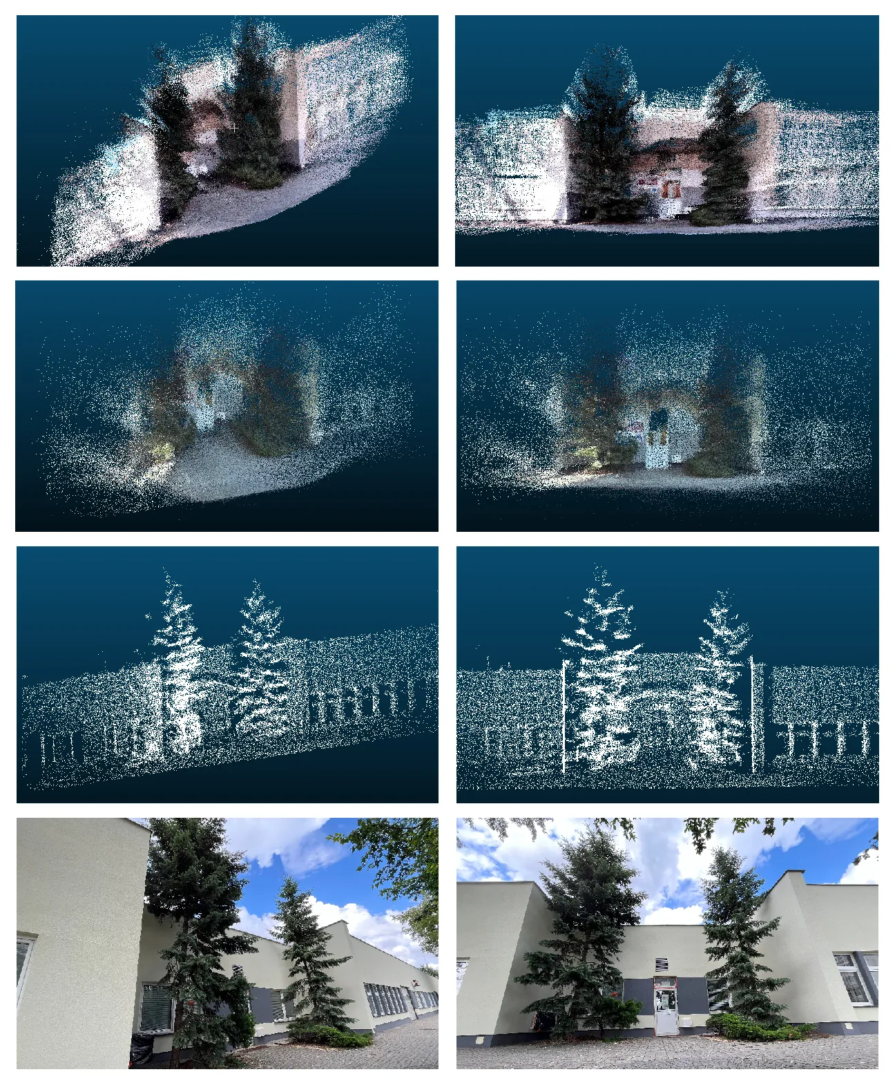
3 Mapping in Agricultural Robotics and Forestry
Dense 3D mapping has become a cornerstone for robust motion planning in agricultural and forestry robots [9]. By capturing detailed geometric and semantic information of unstructured outdoor environments, dense maps enable planners to generate safe, efficient trajectories through crop rows, orchards, vineyards, and forest understories. The literature offers a variety of complementary approaches, ranging from volumetric grids and octrees to surfel-based reconstructions, mesh representations, and deep-learning-enhanced depth completion, that together form a rich ecosystem of mapping tools [219].
In this Section, both agricultural and forestry environments are addressed within a common analytical scope, as they present complementary yet distinct challenges for dense 3D mapping. From a mapping perspective, the primary difference lies in terrain geometry and vegetation structure. Agricultural environments typically feature relatively flat and structured fields, where the terrain is uniform and obstacles are limited to crop rows or isolated plants. In contrast, forestry environments are characterized by uneven topography, dense canopy layers, and complex occlusions, which complicate perception and traversability estimation. Despite these differences, both domains rely on high-fidelity, dense mapping techniques capable of capturing vegetation, terrain, and hidden obstacles to support safe and efficient motion planning. Therefore, the mapping approaches are discussed jointly in this section, as most techniques are transferable and can be adapted to both environments.
3.1 Volumetric Occupancy and Surface Reconstruction
Volumetric occupancy grids and truncated signed-distance functions (TSDFs) provide dense representations of free and occupied space [220]. ColMap leverages a memory-efficient grid that compresses vertical structures into column boundaries, reducing onboard memory requirements for large-scale fields. Similarly, [221] extend TSDF fusion to LiDAR data, integrating loop closures in a graph-SLAM backend to maintain global consistency over kilometers of terrain. For Micro Aerial Vehicles (MAVs), [183] demonstrate continuous-time 3D mapping with a passively actuated 2D LiDAR, yielding smooth, high-resolution point clouds under tree canopies. In rough terrain, [222] employ a multiresolution surfel map, storing oriented surface elements in nested grids, to achieve drift-free odometry and real-time 2.5D heightmap extraction for traversability analysis.
Building on these foundations, [223] propose Stochastic Triangular Mesh (STM) mapping, which incrementally fits Bayesian triangular facets with surface roughness priors, capturing fine-scale undulations (e.g., furrows, root mats) with linear computational cost. STM meshes naturally support planners requiring smooth terrain models and gradient information for wheel or legged locomotion.
3.2 Multi-Resolution and Feature-Based Data Structures
Adaptive resolution structures accelerate collision queries and reduce memory. [161] present an octree of occupancy log-odds augmented with explicit free-space voxels, dynamically refining geometry near obstacles (e.g., tree trunks, crop stems) and coarsening open areas. This yields logarithmic-time replanning suited to dense row crops or forest understories. In parallel, [224] adapt the LOAM pipeline for small-FoV solid-state LiDARs, extracting planar and edge features from irregular scans and maintaining high-precision odometry and mapping on resource-constrained platforms.
For pose refinement, [225] introduce BALM, which performs local bundle adjustment over sliding windows of LiDAR keyframes. By analytically eliminating feature parameters, BALM refines 20 keyframe poses at 10 Hz, producing globally consistent maps essential for collision-free trajectory planning.
| Name | Reference | Description | Modality | Sim/Real |
|---|---|---|---|---|
| RELLIS-3D | [213] | A multimodal dataset collected in an off-road environment | Lidar, RGB | Real |
| ReplicaCAD | [216] | A photo-realistic 3D indoor scene reconstruction dataset, recreated from the ‘FRL apartment’ in Replica, with variations in furniture placement. | 3D Indoor Reconstruction | Simulated |
| ScanNet | [226] | 1,513 real-world indoor scans captured by RGB-D camera, including calibrated camera poses, semantic labels, and surface reconstructions. | RGB-D Scans | Real |
| KITTI | [227] | Urban outdoor V-SLAM benchmark integrating stereo cameras, LiDAR, GPS, and IMU, widely used for odometry and mapping research. | RGB, LiDAR, GPS, IMU | Real |
| Public dataset HKU MaRS | [228] | Calibration datasets from HKU MaRS Lab for evaluating multi-sensor calibration algorithms. | Calibration | Real |
| The Campus dataset from LIO-SAM | [229] | A 1,437 m campus trajectory recorded with LiDAR and IMU, used to evaluate LIO-SAM. | LiDAR/Inertial | Real |
| shapeNet | [218] | Synthetic object-level models for supervised encoder–decoder training, covering 55 common object categories. | Synthetic 3D Models | Simulated |
| Redwood dataset | [230] | Apartment-scale RGB-D sequence ( 31,910 frames) with high-quality ground-truth mesh, designed for self-supervised fusion. | RGB-D, Mesh | Real |
| flat dataset | [231] | Simulated environment with complete ground truth over two trajectories featuring moved, added, or removed objects. | Simulated Environment | Simulated |
| RIO dataset | [232] | Multi-run reconstructions of real indoor scenes for evaluating mapping consistency over time. | RGB-D | Real |
| TUM RGB-D dataset | [233] | Kinect-based video sequences with RGB, depth, and ground-truth camera trajectories for SLAM benchmarking. | RGB-D Video | Real |
| ICL-NUIM dataset | [233] | Synthetic RGB-D sequences under varying illumination, created to test SLAM robustness. | Synthetic RGB-D | Simulated |
| Newer College dataset | [215] | Hand-held LiDAR+IMU run on Oxford campus with centimeter-level noise, representing a challenging outdoor mapping scenario. | LiDAR | Real |
| Neural RGB-D Dataset | [234] | Small-room scale RGB-D scenes for testing generalization of learning-based mapping algorithms. | RGB-D | Real |
| ModelNet40 dataset | [235] | Synthetic object point clouds (40 categories) for object-level shape understanding. | Synthetic Point Clouds | Simulated |
| Cityscape dataset | [236] | Urban driving images with per-pixel semantic and depth ground truth for segmentation and depth estimation. | RGB Images, Depth | Real |
| KAIST urban dataset | [237] | Multi-modal urban driving sequences (camera, LiDAR) for autonomous vehicle perception. | Urban Imagery | Real |
| EuRoC Machine Hall | [238] | Industrial indoor RGB-D sequences from a cluttered machine-hall environment, captured with synchronized IMU. | RGB-D | Real |
| Matterport3D | [239] | 90 large-scale indoor RGB-D scans captured with Matterport Pro; includes ground-truth meshes and camera poses. | RGB-D | Real |
| OctoMap 3D scan dataset | [92] | Real 3D point-cloud scans for building octree-based occupancy maps using OctoMap. | 3D Scan | Real |
| 3DRef | [240] | Multi-return LiDAR and RGB images with semantic labels in indoor scenes (\(\approx\) 50k samples) for reflection detection. | LiDAR, RGB, Semantic | Real |
| nuscenes | [241] | Urban driving dataset with synchronized LiDAR, cameras, and annotated objects, designed for domain transfer evaluations. | Multi-sensor (LiDAR, etc.) | Real |
| Challenging data sets for point cloud | [214] | Curated point-cloud sequences posing registration challenges (e.g. foliage, dynamic objects). | Point Clouds | Real |
| Utbm dataset | [242] | Long-term autonomous driving sequences with LiDAR and cameras, collected across changing seasons in Europe. | Autonomous Driving Sensors | Real |
| NCLT dataset | [243] | Raw LiDAR, omnidirectional camera, and ground-truth localization data collected on University of Michigan campus. | LiDAR, Camera | Real |
| TartanAir dataset | [217] | Unreal-Engine–based virtual environments with varied lighting, weather, and dynamics for training DROID-SLAM and similar systems. | Virtual RGB-D | Simulated |
| MaiCity Dataset | [244] | 100 m noise-free synthetic LiDAR scans (64 lines) and ground-truth city model for urban mapping benchmarks. | LiDAR | Simulated |
| Bunker DVI Dataset | [169] | DVI sensors (passive stereo, active stereo, ToF) in a 1,600 m2 bunker-like environment for search-and-rescue evaluations. | DVI Sensors | Real |
| Oxford RobotCar Dataset | [245] | Multi-sensor (images, LiDAR, GPS/INS) data collected in central Oxford under varying weather and illumination, for mapping and detection tasks. | Images, LiDAR, GPS/INS | Real |
| Argoversev | [246] | Large-scale autonomous driving dataset with LiDAR and camera imagery, designed for perception and forecasting research. | Autonomous Driving Sensors | Real |
In parallel, recent work has explored Mesh-SLAM integrated with IoT edge–cloud architectures for agricultural mapping, demonstrating high-resolution farm-scale reconstructions from monocular cameras streamed to edge nodes and fused in the cloud [247].
3.3 Semantic and Collaborative Mapping
Embedding semantics into dense maps allows motion planners to differentiate terrain and crop structures [247]. [248]’s AgriColMap fuses UAV-derived orthophotos with Unmanned Ground Vehicle (UGV) LiDAR scans via dense optical flow, creating unified 3D vegetation-index models that guide both aerial survey routes and ground interventions.Surveys by [7], [8], [249] highlight the growing trend of mixed-platform mapping and semantic perception for precision farming tasks.
Learning-based terrain classification has been explored by [250], who train supervised models on synthetic 3D scans to discriminate traversable soil from obstacles. Šálanský et al. [251] propose a KKT-loss to enforce consistency between predicted “supporting terrain” and actual robot poses, correcting heightmaps under soft surfaces such as grass or leaf litter. In vineyards, [252] build high-resolution water-potential grids using spectral and thermal sensors, enabling irrigation planners to route Automated Guided Vehicles (AGVs) where water stress is greatest. Interactive segmentation tools further democratize boundary mapping: [253] develop a click-based deep-learning system for rapid field-edge delineation on orthophotos, achieving near real-time inference and centimeter-level accuracy that directly informs coverage path planners.
3.4 Depth Completion and Sensor Fusion
Dense reconstructions often rely on fusing sparse LiDAR with vision. [254] introduce a scalable Gaussian-process depth-completion framework (KISS-GP) that balances monocular inference with sparse range measurements, yielding sharp, discontinuity-preserving maps. Complementarily, [255] enforce scanline resolution invariance to generate dense, high-quality depth from low-channel LiDARs combined with RGB images critical for under-canopy mapping with lightweight sensors. Polarimetric cues offer another avenue: [256] combine polarization measurements with deep depth priors to disambiguate surface normals in texture-poor canopy regions, enhancing map density for collision checking. Binary anisotropic diffusion tensor regularization by [257] further refines depth completion to preserve sharp edges at occlusions.
3.5 Agriculture-Specific Dense Mapping
Recently, neural-based models have gained popularity in agriculture because they require only camera images while achieving high-precision 3D reconstructions. PAg-NeRF [258] introduces a novel NeRF-based framework that generates dense and continuous 3D representations of agricultural environments. Trained directly from image sequences with noisy odometry and inconsistent panoptic labels, the model reconstructs both detailed scene geometry and photorealistic structure. As a result, it produces a geometrically accurate, dense, and panoptically consistent model of the environment, suitable for panoptic segmentation and fruit detection in 3D space. The study in [259] demonstrates that NeRF achieves reconstruction quality comparable to leading commercial Multi-View Stereo software such as Reality Capture, while excelling at novel-view image synthesis. Despite its limitations in training speed and geometric accuracy under sparse sampling, NeRF remains a powerful tool for generating dense, multi-representational 3D models. However, its applicability is constrained when modeling large regions.
The most commonly used sensor for mapping in agriculture is LiDAR. The TreeScope dataset [260] provides LiDAR data collected in agricultural environments using robotic platforms, including UAVs and mobile robots. Each dataset contains ground-truth lidar–inertial odometry and velocity-corrected point cloud frames for every LiDAR sweep. The data are processed using the Faster-LIO framework, ensuring high-accuracy localization and temporally consistent 3D reconstruction. AgriColMap [248], a map registration framework, integrates UAV and UGV data to align aerial and ground maps of agricultural environments using a grid-based multimodal representation that combines vegetation indices and surface models. The method formulates map alignment as a dense optical flow estimation problem, where dominant correspondences are selected through a voting scheme for non-rigid alignment, followed by a refinement step that focuses on relevant map regions to achieve accurate and robust registration.
RGB-D cameras are significantly less popular due to their inability to operate in direct sunlight, but are still used in shaded areas, particularly for fruit detection and mapping. Gai et al. [261] presented a system that provides inter-row vehicle positioning data in agricultural fields when a prior field map is available, but localization reliability is limited. The system was validated in real field conditions, achieving mean absolute errors below 5 cm under various conditions. The study also demonstrates the potential of using RGB-D and Time-of-Flight (ToF) cameras for under-canopy navigation, especially for lateral positioning within crop rows. In practice, RGB-D sensors are more commonly applied to short-range measurements and mapping tasks, including shape recovery of fruits from partial views [262], [263] and fruit picking [264].
Mapping in agriculture not only focuses on representing the environment as a set of obstacles for collision avoidance but also incorporates semantic information, such as the positions of fruits or branches [265]. Robots detect fruits and bunches and estimate their position and quality to enhance the speed and cost-effectiveness of automated harvesting. Lobefaro et al. [266] introduce a system for long-term fruit tracking using 3D data, capable of generating instance-segmented 3D representations of plants across different growth stages. The method relies solely on consumer-grade RGB-D cameras mounted on a mobile robot, performing instance segmentation on each image in a sequence and tracking corresponding instances over time using geometric and depth information, ultimately producing a 3D semantic point cloud aligned with odometry data.
3.6 Forest-Specific Dense Mapping
Forestry environments pose unique challenges, thick foliage can interfere with GNSS reception, and undergrowth complicates traversability. [267] develop ForestTrav, a LiDAR-only sparse CNN that predicts per-voxel traversability scores from occupancy statistics, enabling ground vehicles to navigate subtropical forests without RGB data. Semantic SLAM approaches such as [268], [269] detect and model tree and vegetation trunks as factor-graph landmarks, maintaining loop closures under dense canopy and producing annotated 3D maps for UAV altitude control and collision avoidance.
Complementary localization techniques, such as GNSS/INS-aided LiDAR-SLAM by [270], achieve centimeter-level forest-stem mapping accuracy by integrating velocity and heading priors into the SLAM backend. Place recognition networks (e.g., Logg3dNet) evaluated by [271] further anchor global consistency by detecting loop closures across large spatial offsets in forest trails.
3.7 Interconnections and Future Directions
Across these domains, common themes emerge:
Memory-efficiency vs. fidelity: Techniques such as ColMap and octree representations trade minor accuracy losses for drastic memory savings, enabling dense maps on embedded platforms.
Multi-resolution fusion: Combining fine detail near obstacles with coarse background modeling (e.g., multi-resolution octrees, STM meshes) accelerates planning without sacrificing local accuracy.
Semantic enrichment: Layering crop and terrain semantics atop geometric maps empowers task-specific planners, whether following rows, avoiding trunks, or targeting irrigation zones.
Deep-learning integration: Depth completion, traversability inference, and scene completion networks enhance map density and robustness under challenging sensing conditions.
Collaborative mapping: Fusing aerial and ground platforms yields large-scale, high-precision maps that unify global coverage with local detail.
Looking forward, tightly coupling mapping uncertainty with risk-aware planners, exploiting active perception to allocate mapping fidelity, and federating multi-robot maps in the cloud will drive the next generation of autonomous agricultural and forestry systems.
4 Mapping Solid Ground under Vegetation in Forestry Areas and Traversability mapping
The review of the dense mapping methods in robotics leads to the new challenging problem of estimating the real terrain profile or risky obstacles covered under vegetation or estimating the traversability maps. Estimating the true ground surface beneath vegetation has been approached from both model-based and learning-based perspectives. Early work by Macedo et al. [272] modeled grass blades as randomly distributed cylinders, showing that LiDAR return heights follow an exponential distribution in homogeneous grass. While this allowed discrimination of vegetation clutter from hard obstacles, it did not directly recover the underlying terrain height. Wellington and Stentz extended this statistical view by embedding ground smoothness, vegetation consistency, and obstacle clustering priors into a hidden semi-Markov model, effectively “peeling away” overlying vegetation to infer the latent ground surface [273].
Proprioceptive–exteroceptive fusion methods close the loop between what the robot expects and what it actually experiences. Wellington and Stentz [274] first demonstrated online adaptation by correlating forward-looking LiDAR/stereo features with actual contact measurements during traversal, continuously refining a regression model of the true support surface. Homberger et al. [275] further refined this idea for legged robots by fusing sparse foothold penetration depths with dense exteroceptive elevation maps in a Gaussian Process framework, explicitly subtracting a deformable vegetation layer to yield a continuous support-surface estimate. This category of models focuses on using proprioceptive feedback to validate and refine exteroceptive traversability predictions especially in environments with dense vegetation or complex obstacles. Table 5 provides a comparative overview of representative proprioceptive–exteroceptive fusion models.
Complementing optical and contact sensing, radar-based voxel mapping has proven robust in adverse conditions. Weidinger et al. [276] introduced a 3D probabilistic voxel map built from millimeter-wave radar scans, using a volumetric inverse sensor model to update occupancy and extract a digital terrain model even through light vegetation, dust, or rain. Table 6 compares mmWave radar and LiDAR systems in terms of their vegetation penetration, ground elevation accuracy, and sensing mechanisms, illustrating the superior canopy penetration and robustness of mmWave radar for reliable ground detection in densely vegetated environments.
Deep learning approaches have recently enabled more powerful semantic filtering and prediction. Li et al. [277] proposed a Semantic Pointcloud Filter that segments rigid versus deformable points from LiDAR+RGB input and self-supervises “hallucinated” ground depths in penetrable regions using future foothold observations. Agishev et al. [278] advanced the field with MonoForce, a grey-box model that predicts interaction forces from monocular images and uses a differentiable physics engine to infer ground compliance, learning to recover the hidden support surface under non-rigid covers.
Building on this work, FusionForce [279] introduces an improved end-to-end differentiable hybrid model that integrates both camera and LiDAR data to predict robot trajectories in challenging off-road environments. It employs a neural-symbolic physics-aware layer that explicitly models robot-terrain interaction forces and simulates physically plausible trajectories. Unlike prior methods, FusionForce leverages both geometrical and physical priors, enabling it to generalize better to unseen, non-rigid terrains. Extensive experiments show that it outperforms purely data-driven and previous hybrid models in both trajectory accuracy and terrain estimation, particularly under vegetative cover. The model is also computationally efficient and interpretable, supporting its deployment in control, SLAM, and planning tasks across forested terrains.
| Model / Approach | Application Focus | Proprioceptive Data Used | Exteroceptive Data Used | Mapping Output / Comparative Advantage |
|---|---|---|---|---|
| ProNav (Proprioceptive Traversability Estimation) [280] | Traversability mapping in environments with dense vegetation and high granularity. | Joint encoders, force sensors, and current sensors (measuring joint position, force, and current consumption). | Integrated with exteroceptive-based perception (e.g., LiDAR, vision). | Improved Success Rate and Efficiency: Up to 40% improvement in success rate and 15.1% reduction in energy consumption compared to purely exteroceptive methods. Assesses terrain stability and resistance to motion to compute optimal gait. |
| Self-Supervised Costmap Learning [281] | General off-road traversability mapping and fine-grained understanding of robot–terrain interactions. | Proprioceptive terrain interaction feedback (e.g., robot velocity, forces, torques). | Exteroceptive environmental data (e.g., LiDAR, camera). | Smoother Navigation: Learns to predict traversability costmaps in a self-supervised manner. Reduced intervention count by up to 57% compared to occupancy-based navigation baselines. |
| Multi-Sensor Ground Mapping [282] | Soil mapping and characterization for highly automated agricultural vehicles (relevant to forestry). | Vertical acceleration of the vehicle’s sprung mass (IMU). | Stereo camera, visible and near-infrared camera, and thermal imager. | Multi-Layer Map: Integrates data to produce multi-layer maps with geometric, spectral, and mechanical soil properties. Proprioceptive data enhances ground firmness and texture estimation. |
| Near-to-Far Learning for Deformable Terrain [283] | Estimating traversability and vehicle configuration in deformable terrain (e.g., loose soil, thick vegetation). | Vehicle configuration and terrain deformation experienced by the robot. | Exteroceptive range sensing for initial rigid-terrain assumptions. | Correlation Learning: Multi-task Gaussian Process framework learns correlation between exteroceptive and proprioceptive feedback (deformation), enabling accurate traversability estimation with uncertainty quantification. |
| Feature | mmWave Radar | LiDAR |
|---|---|---|
| Penetration [284] | High; capable of penetrating vegetation canopy to detect the ground profile even in dense foliage. | Limited penetration; signal is attenuated or scattered by foliage, reducing effectiveness in dense vegetation. |
| Ground Elevation Accuracy [284] | High accuracy; mean error for ground elevation measured near zero (\(\sigma \approx 0.4\) m) in forested environments. | Lower accuracy; mean ground error reported around \(-0.37\) m (\(\sigma \approx 0.25\) m) under similar conditions. |
| Mechanism [284] | Measures backscatter signal variation through vegetation to identify the ground echo peak, providing canopy penetration and sub-surface profiling. | Measures time-of-flight of light pulses, which are often blocked or scattered by vegetation, limiting ground detection reliability. |
| Robustness in Degraded Visual Environments [285] | Maintains persistent perception in dust, fog, rain, and low-light conditions; robust against degraded visual environments (DVEs). | Performance significantly degraded by atmospheric disturbances such as dust, fog, or lack of visual contrast. |
| Ground Segmentation Capability [285] | Demonstrated ability to classify ground reliably in low-visibility and mixed-terrain conditions. | Struggles with interpretation and segmentation in poor visibility; prone to false surface detections. |
| Range Accuracy [285] | High range accuracy maintained across environmental conditions; superior to optical sensors in challenging terrain. | Range accuracy compromised by environmental factors and reflective surface inconsistencies. |
Traversability mapping in vegetated terrain builds upon these ground estimates by adding surface geometry and appearance to cost-map construction. Ruetz et al. [286]’s ForestTrav maintains a probabilistic 3D voxel grid populated by multi-return LiDAR statistics, then applies sparse 3D convolutional networks to predict per-voxel traversability that distinguishes pliable vegetation from solid obstacles. Schilling et al. [287] fused geometric features (slope, roughness) with semantic labels from camera images in a random forest, leveraging both true ground geometry and surface appearance under vegetation.
Self-supervised traction-aware methods such as WayFAST [288] use online wheel slip and sinkage estimates to label RGB-D data with actual traction cost, allowing avoidance of non-geometric hazards like wet grass. An example of such self-supervised annotation based on trajectory elevation is shown in Fig. 13. Overbye and Saripalli [289] demonstrated that millimeter-wave radar alone can support 2.5 m/s off-road navigation by adapting LiDAR ground-plane and obstacle detection to radar returns, exploiting radar’s vegetation penetration.
Vision-only self-supervised frameworks have emerged for rapid deployment. Frey et al. [290] and Mattamala et al. [291] showed that pre-trained high-dimensional features (e.g. DINO-ViT) can be fine-tuned online in minutes using proprioceptive feedback to produce dense traversability maps, effectively learning to see through grass and undergrowth from just a brief demonstration. Chen et al. [292]’s ORDformer further fuses monocular images and LiDAR via deformable attention to perform 3D semantic scene completion with explicit traversability costs, yielding substantial improvements in the accuracy of off-road scene representation.
Finally, Recently, Schreiber and Driggs-Campbell [293] introduced CHUNGUS, a human-in-the-loop framework for traversability estimation that builds on vision foundation models (DINOv2) and feature upsampling. Their system performs real-time pixel-wise traversability prediction and incorporates online learning via sparse human annotations, prompted only when the system detects unfamiliar visual inputs through a novelty detector. Unlike traditional self-supervised approaches, CHUNGUS avoids the risks of teleoperation by relying on relative pairwise labels and achieves state-of-the-art performance in both simulated and real-world environments.
| Paper | Year | Approach | Sensors | Ground Est. | Traversability |
|---|---|---|---|---|---|
| Homberger et al. [275] | 2019 | GP fusion of penetration | Depth camera, Haptic | Yes | No |
| Weidinger et al. [276] | 2020 | Voxel-map with inverse sensor model | mm-wave Radar | Yes | No |
| Li et al. [277] | 2023 | Semantic Pointcloud Filter | LiDAR + RGB | Yes | No |
| Agishev et al. [278] | 2024 | Physics-informed deep model | Monocular RGB | Yes | No |
| Ruetz et al. [286] | 2022 | Voxel-based NDT + 3D CNN | LiDAR | No | Yes |
| Schilling et al. [287] | 2017 | Random Forest fusion | LiDAR + Camera | No | Yes |
| Gasparino et al. [288] | 2022 | Slip-based self-supervision | RGB-D + Proprioception | No | Yes |
| Overbye & Saripalli [289] | 2023 | Radar-only ground/obstacle detection | mm-wave Radar | No | Yes |
| Frey et al. [290] | 2023 | Online self-supervised vision | RGB + Proprioception | No | Yes |
| Mattamala et al. [291] | 2024 | Pretrained features + online learning | RGB + Proprioception | No | Yes |
| Chen et al. [292] | 2024 | Deformable attention scene completion | LiDAR + RGB | No | Yes |
Together, these works illustrate a progression from purely statistical models to hybrid physics-informed deep learning and self-supervised frameworks. By integrating generative priors, proprioceptive feedback, radar robustness, and advanced neural architectures, modern systems achieve real-time, high-fidelity estimation of both the hidden ground surface and traversability beneath even the densest vegetation. Table 7 provides a side-by-side comparison of solid-ground estimation and traversability-mapping methods under vegetation.
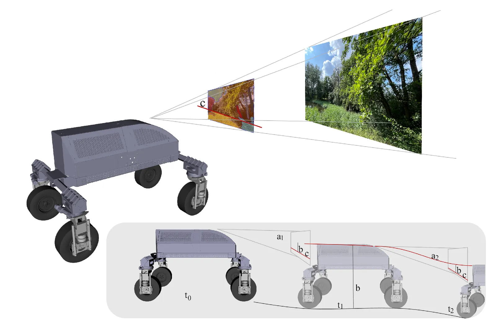
5 Conclusion
This survey provides a comprehensive overview of mapping methods relevant to agricultural robots operating in vegetative environments. An examination of sensor modalities including cameras, LiDAR, radar, and RGB-D sensors was conducted to analyze their capabilities and limitations in capturing spatial information under challenging conditions. Mapping techniques were then classified by data structures and cell content, covering grid-based, hierarchical, and semantic maps, and the relevance of publicly available datasets for benchmarking was discussed.
Emerging trends and specialized approaches have been identified in the context of agricultural and forestry robotics. Volumetric mapping, multi-resolution representations, and semantic fusion have been deemed increasingly important for the understanding of complex outdoor environments. Specific challenges such as depth completion under vegetation are highlighted, and the need for flexible and robust solutions to ensure robotic operational safety is emphasized. In forestry scenarios, unique difficulties are encountered when terrain structure is obscured by dense vegetation, and specialized methods for solid ground estimation and traversability analysis are necessitated.
The review concludes by emphasizing the importance of continued research into adaptive, multimodal mapping systems that integrate heterogeneous sensors and hierarchical representations. Future advancements will center on learning-based approaches, real-time fusion, and scalable architectures capable of generalizing across diverse environments. These developments are essential to enable safe, efficient, and intelligent navigation for agricultural and forestry robots in complex natural settings.
Acknowledgment
The research was conducted under the Applied Doctorate Programme of the Polish Ministry of Science and Higher Education, realised in the years 2024–2028 (Agreement No. DWD/8//0080/2024)
Disclosure
The authors acknowledge the use of a large language model solely for editing and grammar enhancement of the manuscript text. No sections of the article, including the main technical content, figures, or images were generated by the AI system. The use was limited to improving readability and language clarity.
References
About the authors

Iman Esfandiyar received the M.Eng. degree in Robotics and Automatic Control from Poznan University of Technology, Poland, in 2020. Since then, he has been a researcher and teaching assistant at the Institute of Robotics and Machine Intelligence, Poznan University of Technology. He is currently pursuing the Ph.D. degree under the Applied Doctorate Programme at Poznan University of Technology in cooperation with the Łukasiewicz Research Network – Poznan Institute of Technology. He has more than 10 years of combined academic and industrial experience in robotics, with expertise in autonomous mobile robots, motion planning, optimization, and artificial intelligence. He has served as a technical lead and participated in several national and EU-funded research projects on autonomous robotics, while actively engaging in international research collaborations.

Dominik Belter , PhD, DSc. graduated from Poznan University of Technology in 2007 and received his PhD degree in robotics from the same university in 2012. Since 2012, he has been an Assistant Professor at the Institute of Control and Information Engineering, Poznan University of Technology, and in 2021 he was appointed Associate Professor. In 2020, he obtained his DSc degree in robotics, also from Poznan University of Technology. Between 2013 and 2016, he worked as a postdoctoral researcher in the Intelligent Robotics Laboratory at the University of Birmingham. Since 2023, he has been a member of the Committee on Automatic Control and Robotics of the Polish Academy of Sciences, and he currently serves as Vice-Chair of the Polish Chapter of the IEEE Robotics & Automation Society (PC-IEEE-RAS). In 2024, he was appointed Director of the Institute of Robotics and Machine Intelligence at Poznan University of Technology. He has participated as an investigator in three European Commission projects and six national projects, leading three national robotics/computer science projects. He is currently the principal investigator of a project on deep learning for motion planning. He serves on the scientific boards of the CLAWAR and EMCR conferences. He is the author or coauthor of more than 110 technical papers in robotics and computer science. His research interests include walking robots, machine learning, computer vision, robot manipulation, and soft computing.
About this page
This page reproduces the full text of the article. Minor editorial differences from the typeset article may exist; the version of record is published in IEEE Access at https://doi.org/10.1109/ACCESS.2025.3638877.
Machine-readable versions: Markdown full text · BibTeX · RIS · llms.txt